Tham Mae Lana - MH0042
19.568717,98.212030
Location
The sink entrance is located at the southwest end of a large closed depression 3km south of Ban Mae Lana. A rough 4WD track leads from the village to within 100m of the cave entrance, but is currently only driveable as far as the northern end of the depression, even in the dry season. From here it is a 20 minute walk down to the cave entrance at the bottom of the depression. Access to the Tham Mae Lana sink entrance, and other nearby caves such as Tham Pakarang, is controlled by local villagers who run a guiding service. The charge is 500 baht for a 4 hour trip. The resurgence entrance is about 45 minutes walk north of the H1095 road. From the parking spot at 47Q 412910 2163640 (which can be identified by the garbage) follow a path to the left through some trees to reach a field that ends at a dry valley. Follow this valley downhill, heading left as the valley starts to descend steeply over tufa waterfalls. The path descends to join the Tham Mae Lana stream a couple of hundred metres downstream of the resurgence. Follow the stream up to the cave entrance. However, there is no path and it becones very overgrown as you approach the entrance. Cave Lodge run tours to the resurgence entrance, calling it Tham Nam Hoo.
Description
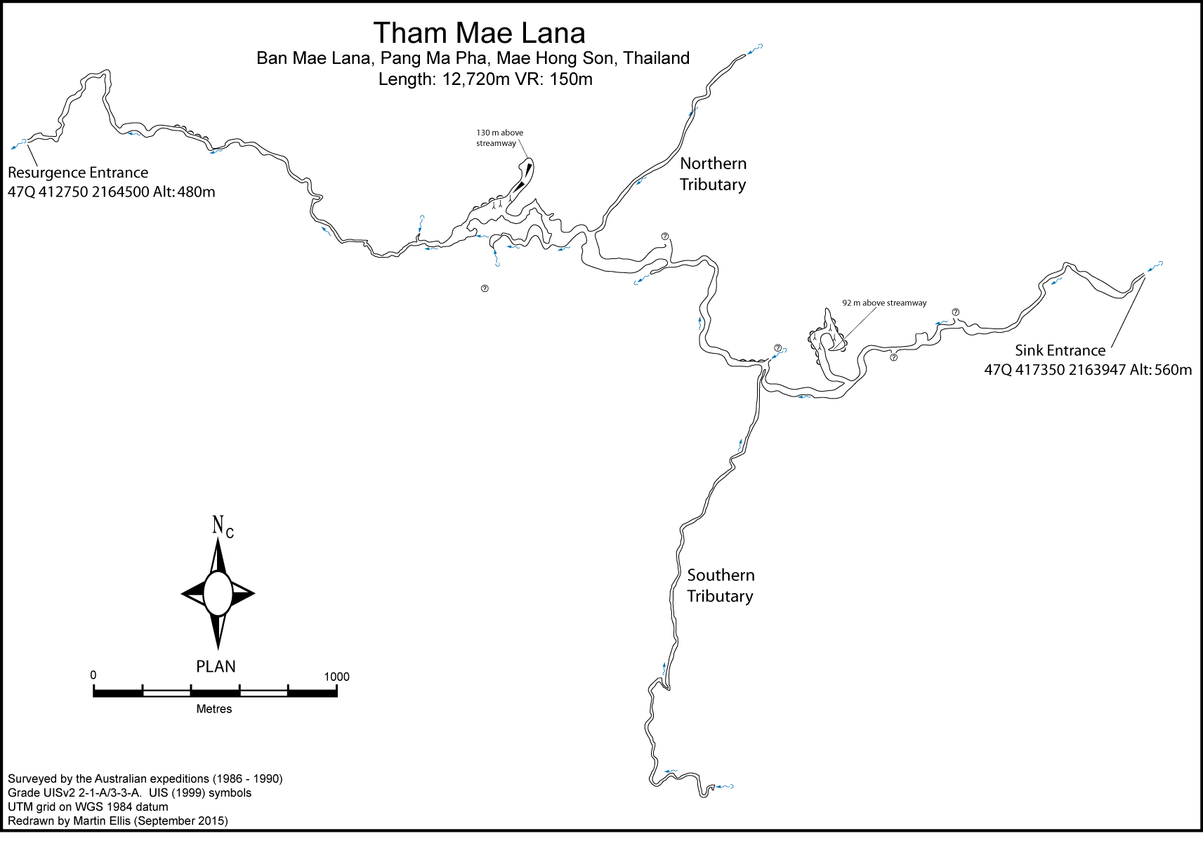
The cave is described from the sink to the resurgence. The sink entrance is 5 m high and wide. From the entrance to the Green Lake, where the stream sumps, is 4.15 km of passage generally 3 to 4 m high and wide with the roof dipping to a minimum of 1.5 m in one place. Around 1.5 km from the sink entrance a large, unexplored, upper level enters from the south. Other high level passages, which are probably still unexplored, are found at 1.7 km, 2.3 km, 3.1 km and 3.2 km from the entrance. Around 2.4 km into the cave at the start of a 300 m long fault controlled passage, a series of large gours, up to 40 m across, rise from stream level to a height of 10 m, completely blocking the passage. Two inlet streams join the main passage here: a small one from the north and a larger one directly opposite from the south, called the Southern Tributary, which flows over large, orange gours into the main stream way. The Southern Tributary is 2.4 km long and starts as a wade through knee deep mud and thigh deep water, which releases sukpherous gases. Conditions improve as progress is made along the passage and the end is reported to be well decorated, with the stream emerging from two sumps. Beyond the Southern Tributary the stream drops down a series of rapids and over an 8 m waterfall. Below the waterfall the stream goes down a small twisting water chute and into a sump after 50 m. A traverse route goes over the top of the falls into a seasonally dry bypass about 10 m above stream level. After 150 m in the bypass passage one reaches a point where the flood waters sink. It is then necessary to ascend a 15 to 20 m high boulder slope above the river and then descend again to the rejoin the stream at Red Crystal Stream with the water emerging from beneath huge boulders to the south. This point is 3.4 km from the sink entrance. As the large main stream passage changes direction from north-south to east-west the Northern Tributary, which is over 1 km long, joins from an upper level on the northern side of the streamway. The way into the Northern Tributary is an obscure and narrow squeeze, but the passage then opens up to be 3 m wide for the first couple of hundred metres and then lowers to a crawl for 30 m. Beyond the crawl the opens up again to be 6 m wide and 15 m high and is heavily decorated with speleothems. Above the streamway there are decorated chambers. A short distance downstream from Red Crustal Stream and the junction with the Northern Tributary the stream again sumps, but progress can be made over rocks and along a dry stream bed for another 100 m until the stream is met again. The stream meanders gently between gravel banks for about 500 m where it ends at a large, green, deep lake about 30 m in diameter where the stream sumps. About 2 m above the lake an inlet stream emerges from a sump before dropping into the Green Lake. About 400 m upstream of the Green Lake, just past the Northern Tributary inlet, there is a steep climb up over muddy rocks which leads up to a series of decorated chambers. Part way up this first boulder slope a 1 m wide, decorated passage heads down in a northwards direction. About 50 m above the river a large chamber with a level mud floor is reached. This area is very well decorated with cave pearls 3 cm in diameter and there is a marked trail through this section of the cave. Beyond the cave pearls the boulder slope continues northwards between a group of 25 m high stalagmites with a calcite flow covering the boulders. This rock fall can be ascended to about 100 m above the stream level. Beyond the high point the passage slopes down into an enormous flat-roofed chamber about 100 to 200 m across. The boulder slope at the north end of this chamber has been climbed almost to roof level, but the chamber has only been looked at briefly and further extensions are possible. Back at the first large high level chamber a descent down a boulder slope leads back down to the main stream which is joined just downstream of where it emerges from a sump. A short distance before rejoining the main stream there is a high level inlet. This has been climbed into and the large tributary pssage followed through some deep pools without reaching a conclusion. From where the main stream is rejoined, after the large high level chambers, there is 3 km of streamway to the resurgence. The stream has a low gradient and alternates between shallow sections between gravel banks and deeper water between sheer rocks. There appear to be several higher level passages above the streamway and in one place a large passage 20 m wide by 10 m high and 20 m above the river has been followed for 150 m without reaching the end. In the last kilometre before the resurgence the cave make a long loop to the north and is well decorated with some long curtains of flowstone. The Mae Lana river emerges from between boulders below a steep cliff at the head of a deep valley. The small cave entrance is in the cliff at the top of the boulder slope.
Hydrology and Geology
The Mae Lana stream sinks in an impenetrable hole (MH0045) in the Mae Lana polje and resurges in a large doline 2 km to the south, passing under a high ridge between. Its course can be accessed from both MH0045 and an intermediate karst window leading to MH0048. From the resurgence the stream flows on the surface for 300 m before plunging into the upstream entrance to Tham Mae Lana.
Topographie
The Tham Mae Lana survey is to a low grade and is known to be incomplete. A resurvey project will probably extend the length of this cave by several kilometres. The 1986 survey of the upper streamway is Grade UISv2 2-1-A and the 1988 surveys of the southern tributary and upper level is Grade UISv2 3-3-A. The rest of the survey is of unknown grade, but the 1986 of the lower streamway and upper chambers is probably Grade UISv2 2-1-A and the 1992 survey of the northern tributary is probably Grade UISv2 3-3-A The following survey data are extant (courtesy of John Brush and John Dunkley): Upstream part of through trip: survey data (no sketch, almost illegible) and map (1986) Southern Tributary: survey data (no sketch) and map on 2 sheets (1988) Upper Level: survey data (with sketch) (1988) Surface traverse: survey data (with sketch) The location of the other survey data (downstream part of through trip, Northern Tributary, etc.) is unknown. Published surveys: DUNKLEY, JOHN ROBERT; BRUSH, JOHN B. (ED.) - without Northern or Southern Tributaries ASF Grade 43/41 BOLAND, KEN (1992b) - shows Southern Tributary ELLIS, MARTIN (2009) - Southern Tributary in wrong location. Ellis, Martin; Laumanns, Michael (2017)
Fauna
Balitora burmanica Hora, 1932 (Chordata, Actinopterygii, Cypriniformes, Balitoridae) (Trajano et al. 2002) Cryptotora thamicola (Kottelat, 1988) (Chordata, Actinopterygii, Cypriniformes, Balitoridae) (Kottelat 1988) Schistura oedipus (Kottelat, 1988) (Chordata, Actinopterygii, Cypriniformes, Balitoridae) (Trajano et al. 2002)
Documents
[Topo] Tham Mae Lana 12/05/2019Bibliography 04/05/2020
- +Anderson, Sally (1999) "Tham Mae Lana Values and Vulnerability" Proceedings of the Conference on Cave Resources, Bangkok, 4-5 August 1999, pp190-202 +Anon. (1997b) "Forward Program: Mini Expedition to North West Thailand" Speleo Spiel No. 303 July-August 1997 p3 +Anon. (2011b) "Baseline study for ecotourism development in Mae Hong Son" Final mission report by Thailand Community Based Tourism Institute (CBT-I) for the United Nations Joint Program on Integrated Highland Livelihood Development in Mae Hong Son, Output 1.3: Ecotourism. June 2011. 175p ***Anon. (2018l) "New walking cavefish study explores origins of quadrapedal walking" New Jersey Institute of Technology press release 19 December 2018 +BAECHLER, ALEX (2000) "Caving In Thailand" Wild Isle Issue No. 12 August-September 2000 pp17-18 +BOLAND, KEN (1989) "Under the Triangle - Thailand 88" Nargun Vol. 21 No. 10 pp90-95 +BOLAND, KEN (1992a) "Caving in Thailand" Australian Caver No. 132 pp7-9 +BOLAND, KEN (1992b) "NW Thailand - The Story So Far" International Caver No. 5 pp30-35 ***Bolger, Terry; Ellis, Martin (2018) "An overview of caves and caving in Thailand" Journal of the Australasian Cave and Karst Management Association No 110 pp32-37 +Borowsky, Richard (1997) "Northern Thailand, the caves of Mae Hong Son" Met Grotto News April 1997. Abstracted by National Speleological Society in Speleo Digest 1997 p326 +BOROWSKY, RICHARD (2000) "Thailand 2001 - Expedition Prospectus" www.nyu.edu/fas/cave/ExpeditionPlan.pdf +BOROWSKY, RICHARD; MERTZ, LISA (2001) "Genetic Differentiation Among Populations of the Cave Fish Schistura oedipus (Cypriniformes: Balitoridae)" Environmental Biology of Fishes Vol. 63 Nos. 1-3 pp225-231 +Breugel, Liedewij van (2013) "Community-based tourism: Local participation and perceived impacts. A comparative study between two communities in Thailand" Master Thesis, Faculty of Social Sciences, Radboud University Nijmegen 83pp +DILOKWANICH, S.; ET AL. (2000) "An Exploration and Database System of the Caves, Mae Hong Son Province" 6 Vols. Faculty of Environment and Resource Studies, Mahidol University, Bangkok - STD-628, STD-629 +DUBOU+, ERIK R.; BOROWSKY, RICHARD L. (2012) "Altered Rest-Activity Patterns Evolve via Circadian Independent Mechanisms in Cave Adapted Balitorid Loaches" PloS ONE Vol. 7 No. 2: e30868. Doi:10.1371/journal.pone.0030868 +DUNKLEY, JOHN ROBERT (1995) "The Caves of Thailand" Speleological Research Council, Sydney ISBN 0-9589253-9-9 +DUNKLEY, JOHN ROBERT; BRUSH, JOHN B. (ED.) (1986) "Caves of North-west Thailand: Report of the Australian Speleological Expeditions 1983-1986" Speleological Research Council, Sydney ISBN 0-9589253-2-1 62pp +DUNKLEY, JOHN ROBERT; GREENFIELD, PAUL (1983) "Under the Golden Triangle: Caving in North Thailand" Australian Speleological Federation Newsletter No. 102 pp4-6 +Dunkley, John Robert; Kiernan, Kevin (1987) "The Australian Speleological Expeditions to Thailand 1985-1986" Helictite Vol. 25 No. 2 p58 +ELLIS, MARTIN (2009) ôThailandÆs Top Twentyö Shepton Mallet Caving Club Journal Series 12 No. 4 pp140-232 +Ellis, Martin (2015c) "Thailand's Longest and Deepest Caves: A Caving Guide" Martin Ellis, Shepton Mallet ISBN 978-1-326-43857-9 84pp +Ellis, Martin; Laumanns, Michael (2017) "Thailand" in Laumanns, Michael; Price, Liz (eds.) (2017) "Atlas of the Great Caves and Karst of Southeast Asia: Part 2 Myanmar - Vietnam" second edition, Berliner Hohlenkundliche Berichte Band 67 pp241-292 ***Fernßndez, Dani (2017) "De cuevas por el Sureste Asißtico. Cap. 2. EspeleologÝa en Tailandia" Club Abismo Grupo Espeleol¾gico 14 September 2017 +Flammang, Brooke E.; Suvarnaraksha, Apinun; Markiewicz, Julie; Soares, Daphne (2016) "Tetrapod-like pelvic girdle in a walking cavefish" Scientific Reports Vol. 6 Article 23711 +JONES, MARK (2013c) "A Trip into Mae Hong Son: Part Two û The Underground River" Megaworldasia blog 4 February 2013 www.megaworldasia.com/2013/02/04/a-trip-into-mae-h… +Kiernan, Kevin (1988a) "Beneath the Golden Triangle" Asia Wise August 1988 pp4-5 +Kiernan, Kevin (1988e) "Geomorphology of a tropical intermontane basin in the Sino-Burman Ranges" 26th International Geographical Congress 1988, International Geological Union, Sydney pp1-24 +Kiernan, Kevin (1991a) "Geomorphological evidence for Quarternary climatic change in the Lower Sino-Burman Ranges" Singapore Journal of Tropical Geography Vol. 12 No. 2 pp112-123 +Kiernan, Kevin (1991b) "Tropical mountain geomorphology and landscape evolution in North-west Thailand" Zeitschrift f³r Geomorphologie N.F. Vol. 35 No. 2 pp187-206 +Kiernan, Kevin (1995) "Genesis 1:31 versus managing the devout: On the spiritual and religious use of karst" 11th Australasian Conference of Cave and Karst Management, Tasmania pp208-221 +Kreuss, Markus (2014) "Thailand" www.troglophil.de/?section=location&id=25 (german) [accessed April 2015] +Kusch, Heinrich (1990) "Die lõngsten und tiefsten H÷hlen S³dostasiens (Stand 1988)" Die Hohle Vol. 41 No. 1 pp11-16 +LAUMANNS, MICHAEL; PRICE, LIZ (2011) "A General Assessment of the Great Caves and the Karst of Southeast Asia" Proceedings of the Asian Trans-disciplinary Karst Conference, Yogyakarta, Indonesia 7-10 January 2011 pp404-419 +PRICE, LIZ (1988) "Whitsun Under The Golden Triangle" Cerberus Spelaeological Society Journal Vol. 18 No. 3 pp65-68 +SAFFORD, KIRK (2002) "Caving By The Light Of The Mekong" The Canadian Caver No. 58 +Sandjideh, Kian (1996) "Read on the net" SFBC Newsletter Vol. 39 No. 9 September 1996, San Francisco Bay Chapter, National Speleological Society, p4 +SATTHA, CHEEWIN (2000) "Rock Blasting Near Rare Cave Draws Fire" Bangkok Post 30 May 2000 +Schuler, Ulrich; Herrmann, Ludger; Ingwersen, Joachim; Erbe, Petra; Stahr, Karl (2010) "Comparing mapping approaches at subcatchment scale in northern Thailand with emphasis on the Maximum Likelihood approach" Catena Vol. 81 pp137-171 +Schuler, Ulrich; Spohrer, Klaus; Herrmann, Ludger; Stahr, Karl (2004) "Variability of soils in a karst catchment of Northern Thailand" in Batelaan, O.; Dusar, M.; Masschelein, J.; Tam, Vu Thanh; Van, Tran Tan; Khien, Nguyen Xuan (eds.) Trans-KARST 2004 Proceedings of the International Transdiciplinary Conference on Development and Conservation of Karst regions, Hanoi, 13-18 September 2004 pp188-191 +SIDISUNTHORN, PINDAR; GARDNER, SIMON; SMART, DEAN (2006) "Caves of Northern Thailand" River Books, Thailand, ISBN 9749863135 +SMART, DEAN (2000) "Cave Management Classification in Thailand: Modification of the Australian Scheme" The Natural History Bulletin of the Siam Society Vol. 48 pp165-175 +SMITH, STEPHEN (1999) "Tham Mae Lana" Der Fledermaus, Flittermouse Grotto, Western North Carolina Vol. 27 Issue 5 pp6-7 +SPIES, JOHN (1997) "The Values and Vulnerability of the Caves and Karst Resources in Mae Hong Son Province, Thailand" Journal of Ecology Vol. 24 No. 3 pp41-48 +Spies, John (1999) "Managing the cave and karst resources in the Nam Khong and Nam Lang catchment, Northwest Thailand" Proceedings of the Conference on Cave Resources, Bangkok, 4-5 August 1999, pp190-202 +SPIES, JOHN (2000) "Suggestions for Cave Management" in "An Exploration and Database System of Caves: Mae Hong Son Province" Vol. 6. Faculty of Environment and Resource Studies, Mahidol University, Bangkok +SPIES, JOHN (2002) "Under The Golden Triangle" in O'REILLY, JAMES & HABEGGER, LARRY (EDS.) "Travelers' Tales Thailand" Travelers' Tales, ISBN 0885211759 pp324-333 +TRAJANO, ELEONORA; MUGUE, NIKOLAI; KREJCA, JEAN; VIDTHAYANON, CHAVALIT; SMART, DEAN; BOROWSKY RICHARD (2002) "Habitat, Distribution, Ecology And Behaviour Of Cave Balitorids From Thailand (Teleostei: Cypriniformes)" Icthyological Exploration of Freshwaters Vol. 13 No. 2 pp169-184 +Vidthayanon, Chavalit (2011) "Cryptotora thamicola" IUCN Red List of Threatened Species. Version 2013.2 www.iucnredlist.org [accessed May 2014] +WIGFALL, MARK (1988) "Cave Lodge, Northern Thailand" Shepton Mallet Caving Club Journal Series 8 No. 5 pp202-205
History
1986 - Following local enquiries from 1983 to 1985 the resurgence was first explored by the Australians early in 1986. As exploration upstream proceeded during the Australian expedition in April 1986 local information led to the location of the doline and the swallet entrance and within a few days Kerry Hamilton and Attila Vrana made the through trip. 1988 -The 1988 Australian expedition surveyed the southern tributary and one of the upper levels in the upstream part of the cave. 1991-12-13 The northern tributary and aragonite chamber was found by Benoit Stinglhamber and Magnus Bj÷rkman 1992 -the northern tributary was surveyed by the 1992 Australian expedition. 1994-02 Stinglhamber, this time with US cavers, explored a third tributary. 2019-03-04 J. Brush, M. Coggan, N. Anderson - trip to resurgence entrance
Caves nearby
| Distance (km) | Name | Length (m) | Depth (m) |
|---|---|---|---|
| 0.4 | Sink MH0343 | ||
| 0.4 | Sink MH0342 | ||
| 0.6 | Tham Nam Tok - MH0048 | 1405 | 0 |
| 0.8 | Tham Phet - MH0266 | 100 | 0 |
| 0.8 | Sink MH0347 | ||
| 0.8 | Cave MH0121 - MH0121 | 160 | 0 |
| 0.9 | Sink MH0355 | ||
| 1.0 | Cave MH0336 | ||
| 1.0 | Tham Pakarang - MH0045 | 948 | 141 |