Phra Wang Daeng (Tham) [PS0028]
16.678397,100.687553
Location
From Ban Chomphu drive through the check point into the national park. Wat Tham Phra Wang Daeng is sign posted to the right (south) about 3 km past the check point. Park at the outside the entrance to the wat and follow the track up the hill to the large entrance.
Description
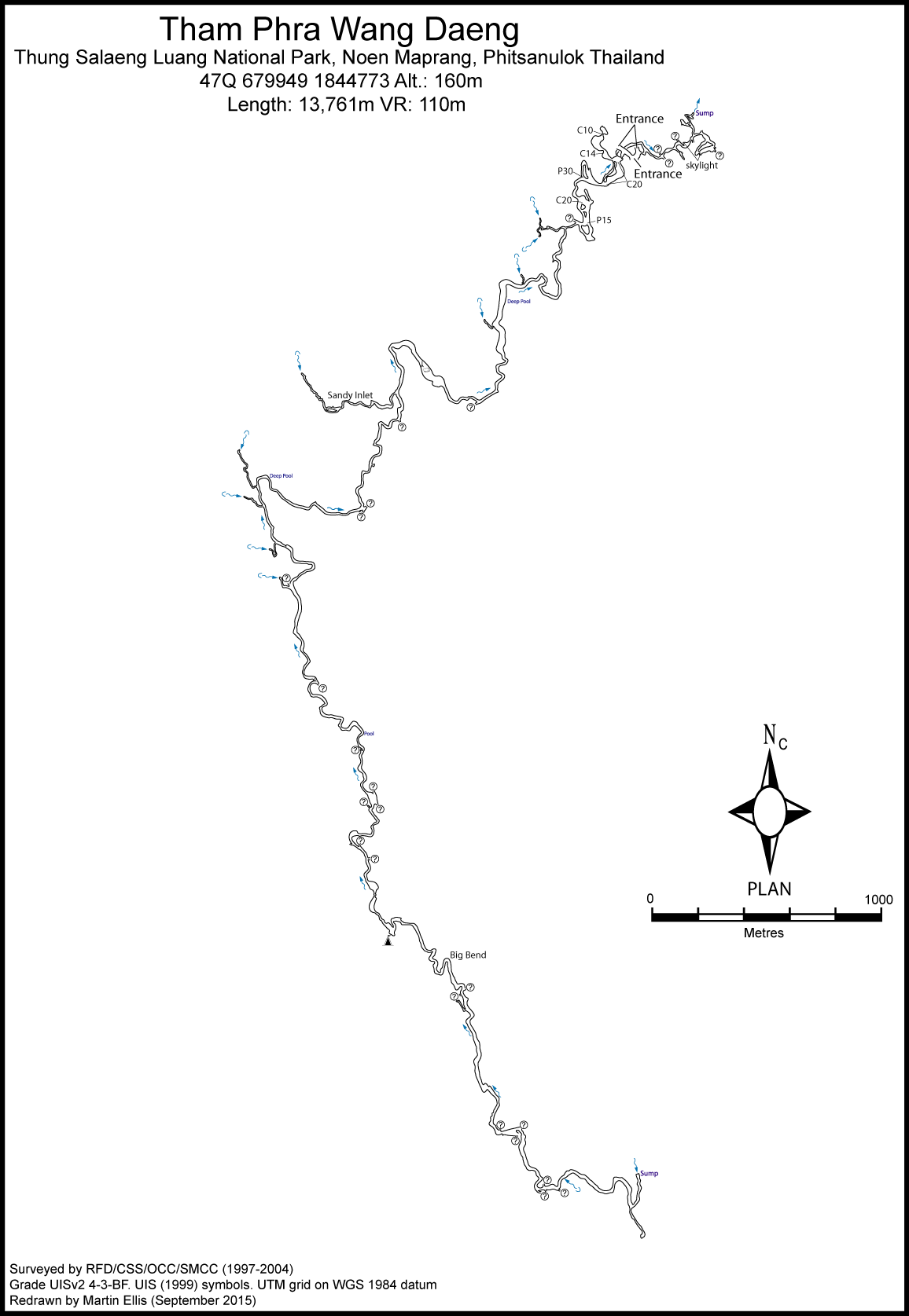
Tham Phra Wang Daeng is the longest cave in Thailand, consisting mainly of a 10 km long streamway it is a magnificent trip. Only one group of cavers has been to the end (monks had been there before them) on a two day camping trip in April 1998. The entrance section of Tham Phra Wang Daeng is a huge collapse chamber with two entrances facing each other. A foot path crosses through the upper levels, passing a golden Buddha and a flat, painted rock symbolising a turtle. Two monk platforms are erected in the middle of the entrance chamber. On the opposite side, the path continues to the downstream entrance of the cave. Descending the steep boulder pile in the entrance chamber, a small hole in the floor has a cellar door gives access to the upstream section of the cave. Inside, the steep descent over huge boulders continues, finally going down a concrete stairway to the bottom of the first boulder choke where the stream is reached. Downstream the water quickly disappears into a boulder choke, but it can be rejoined after a few hundred meters from the downstream entrance. The section of Tham Phra Wang Daeng downstream from the entrance, though nowhere near as long as the upstream section, is characterized by a sequence of small cascades. Heading upstream some gours damming the stream soon lead to the first swim. Here a steep climb to the left (as seen in the downstream direction) leads up to a large Buddha statue, while an even steeper climb to the right over muddy flowstone, rigged by the local monks with a thick knotted rope, leads up for 30 m to an upper dry gallery. Again, the passage is dominated by a golden Buddha statue. At the far end of the bypass a slippery boulder pile leading down to the stream has to be negotiated, this time without the help of a handline. Thus, the bypass can be used to avoid the first swim. Back down at stream level, a large pool is found, which hosts an abundance of white cave fish. Progressing upstream from the first pool the passage obviously leaves the entrance area, which is dominated by its huge boulder choked sections, giving way to several hours of walking, swimming and bouldering along the main streamway. The size of the streamway starts at 10 m wide and 5 m high, but increases to a width of 25-30 m and a height of 20-25 m. Only a few minor inlets are passed, all of them dry at the end of the dry season. After a little over 2 km, a second huge collapse area is reached. The entire river passage is blocked by a huge boulder choke which gives access to a large, dry boulder chamber at roof level. Here a major fault zone is intersected by the cave, as a result of which the ceiling has collapsed to the overlying sandstone, burying the stream passage for approximately 100 m. A tiny red string marks the best way through this unstable zone was placed by the monks. After passing the second boulder choke the active passage continues in a southerly direction. At a false junction a dead end passage leads straight ahead while the streamway makes an obvious easterly turn. The dimensions of the gallery become smaller again with an average passage size of 10 m by 15 m. The phreatic origin of the passage is more obvious here with an elliptic tube in the upper part of the section and a meandering vadose streamway cutting into the lower parts. In two places the streamway is almost entirely blocked by flowstone and at a small cascade a basaltic dyke intersects the passage. Roughly 3 km from the second boulder choke the passage enters a huge fault, leaving the ceiling some tens of meters higher. A sizeable, but seasonal inlet enters from the left û The Sandy Inlet. The cave continues as a tall, meandering vadose canyon and progress is easy walking on gravel banks. A sharp bend to the right is reached where large boulders need scrambling over. An unexplored upper level goes off from here and a 20 m tall column stands on a ledge high above the floor. Beyond the boulders the main stream tunnel continues around several bends. Fins of basalt dykes cross the cave in several places and small rapids flow over flowstone. About 350 m beyond the boulders a deeper pool of water requires wading at a sharp right and bend. A little further on another upper level enters from the right. More easy walking over gravel banks and through shallow water leads to a point where large boulders almost block the cave. It is possible to climb up through the boulders for 15 m and enter a large chamber above. Care is needed on the climb as some boulders are loose. Unexplored upper levels lead off in two directions. Scrambling down a brown flowstone cascade on the opposite side of the chamber reaches the stream again. Immediately upstream of the boulder room a small inlet enters the cave via a 10 m high aven. About 50 m further is a low flowstone roof and this is the only place where hands and knees crawling is required in the main stream passage. There is a very powerful draught through this low section. After the low section easy walking in a round tunnel passes an unexplored inlet on the right and two upper levels on the left. The passage rises in height to become a canyon again and widens out at a round chamber where a vadose canyon carries the stream through the middle of the room. At the far end of this chamber a short scramble over boulders leads back to the stream and the passage continues. The passage is small in places and crosses many basalt dykes. A sharp left hand bend is reached after about 200 m, the exploration and survey trip that reached the end of the cave camped in some large sand filled gours located on this bend. Shallow wading continues to a boulder pile which is easily passed on the right to regain the larger stream tunnel. Basalt dykes start to increase in number again and at a sharp right hand bend a boulder room is reached where the right hand wall is formed by the dyke. Climbing over the boulders and down the other side is the way through to a short section of streamway and more boulders. Beyond here, about 350 m past the camp, the stream tunnel assumes large proportions again and continues very spectacularly for about 1 km. The canyon soon reaches a place called the 'Big Bend'. Here the 10 m wide and 20 m high passage turns nearly 180¦ to the right and an excellent view is seen down both tunnels from the outside edge. Continuing past here the tunnel turns a few meanders, passes an aven inlet on the left, an upper level on the right and a large walking sized inlet which is also on the right. A huge vadose canyon, 20 m high and 10 m wide, disappears on into the dark ahead. This passage heads south and is almost straight for about 350 m, following a basalt dyke in the roof. Easy walking on gravel banks allows the explorer to get a good look at this superb section of cave. At the end of the canyon a prominent basalt dyke crosses the cave and the passage bends to the left. Passing a large tilted boulder of flowstone the cave becomes smaller and one wall consists of cemented gravel and cobbles. After a low flowstone roof an upper level enters and a basalt dyke crosses the passage. A large boulder room now opens up ahead, the third major boulder room in the cave and one of the largest. A large number of complicated routes may be taken over, under and through the boulders, but basically it is easiest to try to keep to the stream and go under. Great care is needed in places as some very large boulders appear to be precariously wedged. Following the boulder chamber the cave has much less impressive proportions. A low and wide passage with a gravel floor continues. In one place it is necessary to crawl for the second time in the cave. Additionally there is no detectable draught after the last boulder chamber. Some 200 m beyond the boulder chamber a sharp limestone shelf projects out into the passage at a left hand bend. A low cawling sized inlet or oxbow enters here and a rift crosses the cave on a fault. A small room opens up with large boulders and an upper level in the roof. The stream continues in a wide and low fashion. A too tight inlet on the right and a short scramble over some nice gours leads into more low and wide passage. This gradually enlarges to a left hand bend where a small inlet enters on the right. The stream turns sharply to the left, the water deepens and the upstream sump is reached 9,637 m from the entrance and 39 m above it.
To do
Unexplored leads: Stn 40 - inlet Stn 70 - large chamber Stn 80 - upper level Stn 163 - pitch down into rift passage Stn 234 - 10m climb to upper level Stn 306 - upper level crosses streamway Stn 307 - inlet Stn 463 - upper level Stn 495 - upper level in two directions Stn 509 - inlet Stn 510 - upper level Stn 512 - upper level Stn 603 - low oxbow/inlet
Topo
KAUFMANN, GEORG; BOLGER, TERRY (1997) - small isometric view of 6.3 km of cave SMART, DEAN (1997b) - 6.3 km of passage SMART, DEAN (1998) - 8 sheet Grade UISv2 3-3-F survey. Bolger, Terry (1999) - survey of the complete cave ELLIS, MARTIN (2009) - republished survey from SMART, DEAN (1998). Ellis, Martin; Laumanns, Michael (2017)
Fauna
Thampramon tonvuthi Ng et Vidthayanon, 2013 (Arthropoda, Crustacea, Malacostraca, Decapoda, Brachyura, Potamidae) û type locality (Ng and Vidthayanon 2013) Macrobrachium spelaeus Cai et Vidthayanon, 2016 (Arthropoda, Crustacea, Malacostraca, Decapoda, Caridea, Palaemonidae) û type locality (Cai and Vidthayanon 2016) Thereuopoda longicornis (Fabricius, 1793) (Arthropoda, Chilopoda, Scutigeromorpha, Scutigeridae) (unpublished record) Neolissochilus subterraneus Vidthayanon et Kottelat, 2003 (Chordata, Actinopterygii, Cypriniformes, Cyprinidae) û type locality (Vidthayanon and Kottelat 2003) Schistura spiesi Vidthayanon et Kottelat, 2003 (Chordata, Actinopterygii, Cypriniformes, Balitoridae) û type locality (Vidthayanon and Kottelat 2003) Cyrtodactylus auribalteatus Sumontha, Panitvong et Deein, 2010 (Chordata, Reptilia, Squamata, Gekkonidae) û type locality (Sumontha et al. 2010) Orthriophis taeniurus (Cope 1861) (Chordata, Reptilia, Squamata, Colubridae) (Goddard and Ellis 2018)
Documents
[Topo] Tham Phra Wang Daeng 18/05/2019Bibliography 19/05/2019
- +BLICK, TONY (2000) "Caving in Thailand" Craven Pothole Club Record No. 60 pp63-5 +Bolger, Terry (1999) "Thailand 1997" Australian Caver No. 148 pp21-26 +Bolger, Terry; Ellis, Martin (2015) "An overview of caves and caving in Thailand" Second Asian Transkarst Conference, 6-8 November 2015, Lichuan, China, 5pp +Bolger, Terry; Ellis, Martin (2018) "An overview of caves and caving in Thailand" Journal of the Australasian Cave and Karst Management Association No 110 pp32-37 +BOROWSKY, RICHARD (1998b) "The cave loaches of Thailand : phylogenetic relationships among populations and species" Selected abstracts from the 1998 NSS Convention in Sewanee, Tennessee, Journal of Cave & Karst Studies Vol. 60 No. 3 pp181 +BOROWSKY, RICHARD; VIDTHAYANON, CHAVALIT (2001) "Nucleotide Diversity in Populations of Balitorid Cave Fishes in Thailand" Molecular Ecology Vol. 10 No. 12 pp2799-2805 +BROOKS, SIMON (2002) "Thailand 1998-1999. Thungyai Naresuan W.L. Sanctuary & Thung Salaeng Luang N.P." The International Caver 2001 pp74-76 +BROOKS, SIMON (2003a) "Recce Proves Successful" Descent No. 173 pp26-27 +BROOKS, SIMON (2003b) "Thailand û October/November 2002" Orpheus Caving Club Newsletter Vol. 39 No. 7 - 10 pp30-36. +BROOKS, SIMON (2003c) "Thailand û October/November 2002" Grampian Speleological Group Bulletin 4th Series Vol. 1 No. 5 pp51-53 +BROOKS, SIMON (2003d) "Cave Exploration in Southern and Central Thailand" The International Caver 2003 pp38-43 +BROOKS, SIMON (2004) "Thailand 2004" Orpheus Caving Club Newsletter Vol. 40 Nos. 10-12 pp54-57 +BROOKS, SIMON (2005) "Orpheus in the Tower Karst" Descent No. 183 p23 +BROOKS, SIMON (2008) "Cave Exploration in Thailand û Some Recent British Cave Exploration" paper presented at 4th European Congress of Speleology, Vercors, 23-30 August 2008 3pp +Cai, Yixiong; Vidthayanon, Chavalit (2016) "Macrobrachium spelaeus, a new species of stygobitic freshwater prawn from Thailand (Decapoda: Palaemonidae)" Raffles Bulletin of Zoology Vol. 64 pp117-122 +COGGAN, MARJORIE; DUNKLEY, JOHN ROBERT; ANDERSON, NEIL (EDS.) (1999) "Tham Sanuk: The Lighter Side Of Caving In Thailand" Canberra, 76pp +DUBOU+, ERIK R.; BOROWSKY, RICHARD L. (2012) "Altered Rest-Activity Patterns Evolve via Circadian Independent Mechanisms in Cave Adapted Balitorid Loaches" PloS ONE Vol. 7 No. 2: e30868. Doi:10.1371/journal.pone.0030868 +DUNKLEY, JOHN ROBERT (1997) "The Caves of Thailand - Addendum 1995-97" Speleological Research Council, Sydney +ELLIS, MARTIN (2005) "Some Caves in Thailand Part 2" Shepton Mallet Caving Club Journal Series 11 No. 8 pp342-357 +ELLIS, MARTIN (2009) ôThailandÆs Top Twentyö Shepton Mallet Caving Club Journal Series 12 No. 4 pp140-232 +ELLIS, MARTIN (2010i) "Shepton in Siam" Shepton Mallet Caving Club Journal Series 12 No. 5 pp262-269 +Ellis, Martin (2015c) "Thailand's Longest and Deepest Caves: A Caving Guide" Martin Ellis, Shepton Mallet ISBN 978-1-326-43857-9 84pp +Ellis, Martin (2018c) "SMCC Thailand Expedition 2018 û Summary" report to the Ghar Pharau Foundation, 5pp +Ellis, Martin; Laumanns, Michael (2017) "Thailand" in Laumanns, Michael; Price, Liz (eds.) (2017) "Atlas of the Great Caves and Karst of Southeast Asia: Part 2 Myanmar - Vietnam" second edition, Berliner Hohlenkundliche Berichte Band 67 pp241-292 +ELLIS, MARTIN; PAUWELS, OLIVIER S. G. (2012) "The Bent-toed Geckos (Cyrtodactylus) of the caves and karst of Thailand" Cave and Karst Science Vol. 39 No. 1 pp16-22 +Goddard, Andy (2016) "Thailand Expedition 2016" Shepton Mallet Caving Club Newsletter Vol. 53 No. 2 April 2016 pp40-43 +Goddard, Andy (2018) "Thung Salaeng Luang National Park, Thailand" presentation at Hidden Earth 2018 +Goddard, Andy; Ellis, Martin (2018) "SMCC Expedition to Phitsanulok and Phetchabun 2018" Shepton Mallet Caving Club Journal Series 13 No. 8 pp337-360 ***Gosset, John (2019) "Exp?dition en Tha?lande du Shepton Mallet Caving Club, du 12 au 21 f?vrier 2018ö 6 March 2019 l'Equipe Sp?l?o de Bruxelles blog [accessed March 2019] +Jones, Colleen (1995a) "Management Suggestions for Caves at Thung Salaeng Luang National Park" Cuso International, unpublished report 10pp +JONES, MARK (2013) "Off the Beaten Track in Phitsonalok: Thung Salaeng Wang National Park" Megaworldasia blog 6 January 2013 www.megaworldasia.com/2013/01/06/off-the-beaten-tr… +KAUFMANN, GEORG (1997) "Thailand 97. Exploration in the National Parks of Thung Salaeng Luang, Thung Saliam, and Sri Nakarind" International Caver No. 21 pp13-18 +KAUFMANN, GEORG; BOLGER, TERRY (1997) "Thailand 1997. Exploration in the National Parks of Thung Salaeng Luang, Tham Chaoram and Sri Nakarind" Canberra Speleological Society Inc. unpublished report for the Royal Forest Department, Bangkok 26pp +KONGIM, BANGON; SUTCHARIT, CHIRASAK; NAGGS, FRED; PANHA, SOMSAK (2013) "Taxonomic revision of the Elephant Pupinid snail genus Pollicaria Gould, 1856 (Prosobranchia, Pupinidae)ö ZooKeys No. 287 pp19-40 +KONGIM, BANGON; SUTCHARIT, CHIRASAK; TONKERD, PIYOROS; PANHA, SOMSAK (2009) "Karyotype Differentiation within the Elephant Pupinid Snail Pollicaria mouhoti (Pfeiffer, 1862) (Caenogastropoda: Pupinidae)" The Natural History Journal of Chulalongkorn University Vol. 9 No. 2 pp201-208 +Kottelat, Maurice (2012) "Conspectus cobitidum: An inventory of the loaches of the World (Teleostei: Cypriniformes: Cobitoidei)" The Raffles Bulletin of Zoology Supplement No. 26 199pp +LAUMANNS, MICHAEL; PRICE, LIZ (2011) "A General Assessment of the Great Caves and the Karst of Southeast Asia" Proceedings of the Asian Trans-disciplinary Karst Conference, Yogyakarta, Indonesia 7-10 January 2011 pp404-419 +Mouret, Claude (2004) "Asia, Southeast" in Gunn, John (ed.) "Encyclopedia of Caves and Karst Science" Fitzroy Dearborn, London ISBN 1-57958-399-7 pp100-104 +NATIONAL PARK OFFICE (2006) "National Parks in Thailand" National Park, Wildlife and Plant Conservation Department, Bangkok 280pp +Ng, Peter Kee Lin, Vidthayanon, Chavalit (2013) "Thampramon tonvuthi, a new genus and new species of cavernicolous crab (Crustacea: Decapoda: Brachyura: Potamidae) from Thailand" Zootaxa Vol. 3652 No. 2 pp265-276 +SMART, DEAN (1997b) "In The Monks Footsteps" Descent No. 137 p23 +SMART, DEAN (1997c) "The Caving Scene: Thailand" The International Caver No. 20 p43 +SMART, DEAN (1998b) "Thung Salaeng Luang National Park Cave Surveying Project" Royal Forestry Department, Bangkok Unpublished report 26pp +SMART, DEAN (1998c) "The Caving Scene: Thailand" The International Caver No. 23 p43 +SMART, DEAN (2000) "Cave Management Classification in Thailand: Modification of the Australian Scheme" The Natural History Bulletin of the Siam Society Vol. 48 pp165-175 +SMART, DEAN (2004) "Project Concept û Protecting the Wang Daeng Karst and Raising its Significance Through Water Analysis" unpublished report Deparment of National Parks 9pp +Srisonchai, Ruttapon; Enghoff, Henrik; Likhitrakarn, Natdanai; Panha, Somsak (2018) "A revision of dragon millipedes I: genus Desmoxytes Chamberlin, 1923, with the description of eight new species (Diplopoda, Polydesmida, Paradoxosomatidae)" ZooKeys No. 761 pp1-177 DOI: 10.3897/zookeys.761.24214 +SUMONTHA, MONTRI; PANITVONG, NONN; DEEIN, GRIDSADA (2010) "Cyrtodactylus auribalteatus (Squamata: Gekkonidae), a new cave-dwelling gecko from Phitsanulok Province, Thailand" Zootaxa No. 2370 pp53û64 +Thoma, Alex (2014) "H÷hlenforschung in Thailand" H÷hlenpost No. 144 pp12-21 +VIDTHAYANON, CHAVALIT; KOTTELAT, MAURICE (2003) " Three new species of fishes from Tham Phra Wang Daeng and Tham Phra Sai Ngam caves in northern Thailand (Teleostei: Cyprinidae and Balitoridae)" Ichthyological Exploration of Freshwaters Vol. 14 No. 2 pp159-174 +VOGT, NILS B. (2013) "Temple Caves & Grottoes in Thailand: A Picture-Guide Book" Booksmango, Bangkok ISBN 978-616-222-160-6 214pp
History
1996-03 D. Smart - collected paratype of Neolissochilus subterraneus & Schistura spiesi 1997-04-25 D. Smart, G. Kaufmann, G. Innes, 2 rangers - surveyed upstream 1997-04-26 D. Smart, G. Kaufmann, G. Innes, L. Fellows, 3 rangers - continued surveying upstream 1997-04-26 T. Bolger, D. Glasco, N. Naksathit - surveying downstream 1997-10-08 C. Vidthayanon - collected paratypes of Thampramon tonvuthi 1998-01-08 C. Vidthayanon, R. Borowsky - collected paratype of Neolissochilus subterraneus 1998-04-21 D. Smart, A. Sorn-Ek, 6 rangers - surveying upper levels at start of streamway. 1998-04-22 D. Smart, A. Sorn-Ek, 6 rangers - continuing upstream survey 1998-04-23 & 24 D. Smart, A. Sorn-Ek, 6 rangers - surveying upstream to sump 1998-04-27 D. Smart, 2 rangers - surveying upstream/downstream connection & Sandy Inlet 1999-12-13 D. Smart - surveying inlet 232 1999-12-14 - surveying inlets 209 & 226 1999-12-15 D. Smart - surveyeing Sandy Inlet 2002-01-30 C. Vidthayanon - collected holotype of Neolissochilus subterraneus & Schistura spiesi 2002-08-27 D. Smart - collected paratypes of Thampramon tonvuthi 2002-08-28 D. Smart, C. Vidthayanon - collected type series of Macrobrachium spelaeus and paratypes of Thampramon tonvuthi 2004-04-03 M. Ellis, I. Hollis, D. Smart, T. Bolger, N. Anderson, rangers - surveying inlets 330, 333, 340 & 354 2004-11-24 D. Smart, P. Wagstaff, R. Bellamy - climbs at end of sandy inlet 2008-11-29 C. Vidthayanon, P. Nang-ngam - collected holotype of Thampramon tonvuthi 2009-11-30 M. Ellis, S. Smith 2016-02-11 P. Dummer, C. Dummer, J. Campbell, S. Howe, K. Batten, J. Biffin, A. Goddard 2016-02-13 P. Dummer, C. Dummer, J. Campbell, S. Howe, K. Batten, J. Biffin, A. Goddard 2018-02-13 M. Ellis, P. Collett - downstream 2018-02-13 P. Dummer, C. Dummer, M. Butcher, M. Clayton, E. Porter, J. Begley, E. Sandford, A. Goddard, W. Vityasakunwong - upstream 2018-02-17 P. Dummer, C. Dummer, M. Butcher, J. Gosset- upstream
Caves nearby
| Distance (km) | Name | Length (m) | Depth (m) |
|---|---|---|---|
| 1.8 | Nam Sai (Tham) [PS0113] | 50 | 0 |
| 2.7 | Tham Nam - PS0062 | 123 | 15 |
| 2.7 | Tham Klaeb - PS0073 | 79 | 5 |
| 2.8 | Resurgence PS0061 - PS0061 | ||
| 2.8 | Chomphu (Tham) [PS0089] | 15 | 2 |
| 2.9 | Tham Pha Kaeo - PS0043 | 1217 | 34 |
| 3.8 | Tham Nam Dan - PS0040 | 2137 | 88 |
| 3.9 | Tham Khun Takhan - PS0091 | 75 | 0 |
| 3.9 | Khun Takhan Shrine Cave [PS0076] | 75 | 0 |