Tham Ki Mi - CM0091
19.363057,98.722776
Location
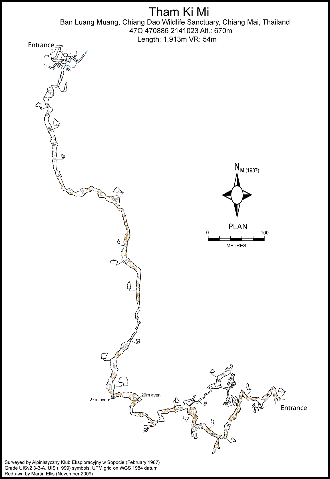
Tham Kimi is on the western edge of Chiang Dao Wildlife Sanctuary, 4 km south of Ban Luang Muang Khong and on the south side of the Nam Mae Moen valley, just east of Ban Yang Mae Moen. From the centre of Ban Luang Muang Khong take the road back towards Chiang Daoas far as the bridge over the left tributary of Mae Nam Taeng. Turn right just beyond the bridge and go through the buildings to the end of the village and then ascend gently to the forest. When it isn't possible to drive a 4WD any further, where the road starts to drop with steep bends, take a good path on the left that leads to the creek. When the path has gone for a few tens of metres to the right and then left into a gorge, there is the start of some fields and then a forest track following the brook. Here take a turning to the left up the path to the cave on a bearing of 270¦ and the entrance which is 50m above.
Description
This is a fine through cave, suitable for parties with limited experience and already included on the itineries of several tour companies. It is well known to the locals. The approach path leads to the resurgence entrance. The resurgence itself is impassable, but an entrance (3m wide by 8m high) is provided by a dry fossil passage 50m up the hill at the end of a fabulous natural canyon festooned with creepers and fig roots. The cave consists of one main corridor leading to an entrance on the other side of the hill and a few side passages, only one of which is extensive. From the entrance the passage goes for 10m before turning sharply to the south-west and down a gentle slope. The passage then turns east and after 30m goes around the two bends to head south and reach a 6m pitch which allows one to descend to the river. The precarious wood and bamboo ladder was replaced with an aluminium one by The Wild Lodge in August 2012. At the foot pf the pitch heading downhill soon reaches an active river passage which flows from east to west for about 60m from the junction to the downstream end. The river passage is of good size, with a width of 1 to 3m at the junction and 8 to 1.2m at the sink. Going upstream the passage is 66m long and the flow is 5l/s (February 1987). The passage is 1.5 x 3m at the start decreasing to 2 x 0.4m at the furthest point explored where the ceiling could be seen to lower further. In the other direction at the bottom of the pitch there is a seasonally dry stream passage that heads south, rising gently. Only here and there is the corridor steeper with rocky steps. The passage width ranges from 1.5 to 10m and it is 10m high. After 100m the passage opens into a large boulder chamber where a narrow gap at the upper end allows one to continue following the passage. The main route continues for several hundred metres right to the swallet entrance, taking two general directions: first south and then east. In a few places the passage expands into the chambers, especially at changes in direction.The floor is covered with boulders, sand and clay. At the bottom of the walls there can be clearly seen clear signs of water erosion. This is a result of high flow during the monsoon rainy season, as the upper entrance of the cave is at the end of a stream bed that periodically has a flowing stream (blind valley). On the walls, roof and floor of the cave there is a lot of white, yellow and brownish-orange speleothems in the form of stalactites, stalagmites, flowstone, curtains and columns. A series of side passages starts in one of the chambers with a narrow 60cm wide by 2.5m high slot, whose floor is covered with sand. After 10m the gap widens to form a passage with a width of 1 to 3m leading to a large chamber with a NE-SW longitudinal axis. The width of the room varies up to 10m and the length is 40m. The floor is covered with sand, clay and bat guano. The chamber also has large numbers of bats. Rich flowstone throughout the whole room gives it a warm bronze color. At the end of the chamber the passage narrows and passes a chimney and ends at a 4m deep blind pits. The continuation of the series of side passages is in the south-east corner of the chamber and goes east. This passgae leads to a junction, whose northern part consists of a relatively narrow rift ending in narrow halls 12m long. The southern branch leads to a large chamber with stalactites and a boulderfloor. A height of this chamber is almost 10m. Although the survey shows this end chamber to be close to the surface and to the main passage no connection could be found. From the upstream swallet entrance a good track around the side of the hill takes you back to the starting point.
Fauna
Nesticella beccus Grall et Jõger, 2016 (Arthropoda, Arachnida, Araneae, Araneomorphae, Nesticidae) (Grall and Jõger 2016) Rhinolophus malayanus Bonhote, 1903 (Chordata, Mammalia, Chiroptera, Rhinolophidae) (Soisook et al. 2008) Rhinolophus microglobosus (Csorba & Jenkins, 1998) (Chordata, Mammalia, Chiroptera, Rhinolophidae) (Soisook et al. 2008) Hipposideros cineraceus Blyth, 1853 (Chordata, Mammalia, Chiroptera, Hipposideridae) (Douangboubpha et al. 2010a) Hipposideros pomona Andersen, 1918 (Chordata, Mammalia, Chiroptera, Hipposideridae) (Douangboubpha et al. 2010b)
Topographie
Alpinistyczny Klub Eksploracyjny w Sopocie (1987) - Grade UISv2 3-3-A Tournier, Thierry (2014b) "Tham Ki Mi" SpÚlÚo 01 No. 26 June 2014 pp175-178
Documents
[Topo] Tham Ki Mi 05/05/2019Bibliography 26/06/2019
- ANON. (1982) Travellers Guide June 1982 CLARAC, A.; PAGAU-CLARAC, H. (1985) "Thailande: Guide Touristique" DK Book House, Bangkok ISBN 974-2104-174 508pp DUNKLEY, JOHN ROBERT (1995) "The Caves of Thailand" Speleological Research Council, Sydney ISBN 0-9589253-9-9 DOUANGBOUBPHA, BOUNGSAVANE; BUMRUNGSRI, SARA; SOISOOK, PIPAT; MURRAY, SUSAN W,; PUECHMAILLE, S+BASTIEN J.; SATASOOK, CHUTAMAS; BU, SI SI HLA; HARRISOM, DAVID L.; BATES, PAUL J. J. (2010a) "A Taxonomic Review of Hipposideros halophyllus, with Additional Information on H. ater and H. cinceraceus (Chiroptera: Hipposideridae) from Thailand and Myanmar" Acta Chiropterologica Vol. 12 No. 1 pp29-50 Douangboubpha, Boungsavane; Bumrungsri, Sara; Soisook, Pipat; Satasook, Chutamas; Thomas, N.M.; Bates, Paul J. J. (2010b) "A Taxonomic Review of Hipposideros bicolor species complex and H. pomona (Chiroptera: Hipposideridae) in Thailand" Acta Chiropterologica Vol. 12 pp415-438 Grall, Elana; Jõger, Peter (2016) "Four new species of the spider genus Nesticella Lehtinen & Saaristo, 1980 from Laos, Thailand and Myanmar and the first description of the male of Nesticella yui Wunderlich & Song, 1995 with a proposed new diagnostic character for the family Nesticidae Simon, 1894 (Arachnida, Araneae)" Zootaxa Vol. 4085 No. 2 pp248-264 PARMA, CHRISTIAN (1987a) "Chiang Dao" Taternik Vol. 63 No. 1 pp34-35 (Polish) PARMA, CHRISTIAN; ROJEK, TADEUSZ (1987) Unpublished notes on 1987 Polish expedition (Polish) PARMA, CHRISTIAN (1988) "Expedition Polonaise Chiang Dao '87" Spelunca No. 30 p9 (French) SIDISUNTHORN, PINDAR; GARDNER, SIMON; SMART, DEAN (2006) "Caves of Northern Thailand" River Books, Thailand, ISBN 9749863135 SOISOOK, PIPAT; BUMRUNGSRI, SARA; SATASOOK, CHUTAMAS; THONG, VU DINH; BU, SI SI HLA; HARRISON, DAVID L.; BATES, PAUL J.J. (2008) "A taxonomic review of Rhinolophus stheno and R. malayanus (Chiroptera: Rhinolophidae) from continental Southeast Asia: an evaluation of echolocation call frequency in discriminating between cryptic species" Acta Chiropterologica Vol. 10 No. 2 pp221-242 Tournier, Thierry (2014b) "Tham Ki Mi" SpÚlÚo 01 No. 26 June 2014 pp175-178 ZEITOUN, VAL+RY; FORESTIER, HUBERT; NAKBUNLANG, SUPAPORN (2008) "PrÚhistoires au sud du Triangle d'Or" IRD Editions, Paris ISBN 97-2-7099-1642-4 252pp
Histoire
1987-02-15 Alpinistyczny Klub Eksploracyjny w Sopocie exploration and survey. 1987-02-16 Alpinistyczny Klub Eksploracyjny w Sopocie exploration and survey. 2014-06-25 (P. Jaeger, E. Grall) collecting spiders
Cavités proche
| Distance (km) | Nom | Longueur (m) | Profondeur (m) |
|---|---|---|---|
| 0.6 | Tham Hup Pha - CM0239 | ||
| 11.0 | Ban Fa Suai Rockshelter [CM0238] | 15 | 0 |
| 11.1 | Tham Mae Pla Ao [Mai Pas Ao Resurgence Cave} [Tham Ban Oui Haen] [Mai Pla Sao] [CM0019] | 1762 | 37 |
| 11.4 | Cave CM0182 - CM0182 | ||
| 11.4 | Cave CM0183 - CM0183 | ||
| 13.0 | Bae Bet (Tham) [Perte de Ban Na Lao] [CM0008] | 40 | 7 |
| 13.1 | Nam Mae Khong (Tham) [CM0253] | 411 | 18 |
| 13.1 | Phra Nam Mae Khong (Tham) [CM0276] | 524 | 38 |
| 13.3 | Cave CM0275 |