Tham Khuha Wari - LO0055
17.171373,101.961684
Location
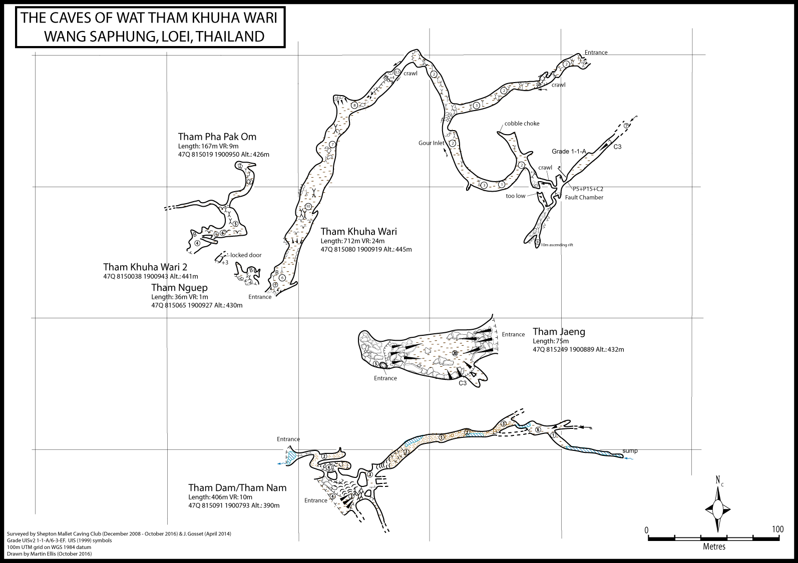
Wat Tham Khuha Khiri is signed to the east of the H201, south of Wang Saphung. At a crossroads in Ban Lat go straight across and at the next village, Ban Sam Nok Chip, go straight on at a sharp right hand bend, then left and soon right. The concrete road goes across the fields to the wat. Inside the wat boundary wall turn left (straight on leads to temple buildings). The dirt track ends at the bottom of the steps up to the cave. The cave is also signed from Wat Tham Khao San Hin on the other side of the hill from Wat Tham Khuha Wari. From Ban Pha Sana take the road south to the east of Phu Pha Sana. The good track ends at the wat where four caves are signed. Take the steps up the hill and Tham Khuha Wari is to the right. Second entrance at 47Q 815351 1901133 alt.: 416m (GPS SMCC December 2008).
Description
Topographie
Surveyed to UISv2 3-3-F by SMCC in December 2008. 20m pitch and rift passage UISv2 2-2-A by John Gosset April 2014. ELLIS (2009) - UISv2 3-3-F ELLIS (2013a) - UISv2 3-3-F Ellis, Martin (2018)
Fauna
Orthriophis taeniurus (Cope 1861) (Chordata, Reptilia, Squamata, Colubridae) (unpublished record)
The 8 m wide entrance opens into a large, dry relict passage. This passage is 100 m long and up to 10 m wide by 15 m high. After 100 m the passage trends to the right and reaches some dry gours. A wooden ladder aids the ascent of the gours where the electric cables continue through a crawl. The crawl is about 10 m long and opens up again into a 5 m wide by 2 to 3 m high passage. This has a dark, guano floor (with some signs of guano excavation) and occasional columns. After about 100 m there is another stal blockage, but again the electric cables disappear into a hole and a short ladder aids the 1 m climb onto a ledge which leads to a crawl. After the short crawl the cave soon ends at the second entrance on the other side of the hill. Between the two crawls there is an inlet with many dry gours. This walking passage leads to a T-junction. Left is choked after 20 m. while right leads to a chamber with false floors. Following the draught takes you through a small crawl into a fault controlled chamber. The draught comes up a 20 m pitch at the back of the chamber. This pitch has been descended (6 m/4 m/10 m sections) to enter a tall rift passage heading north-east. This ascends up a rock slope and although close enough to the surface to smell fresh air it was not possible to see daylight. Back in the chamber above the pitch a rift at the southern end gives access to a 1 m drop down into a decorated passage. To the right the passage closes down after about 20 m. To the left the passage continues for 20 m before becoming choked with stal. At the end a rift was seen to ascend for about 10 m.
Documents
[Topo] Tham Khuha Wari 07/05/2019Bibliography 12/03/2020
- AGGIMARANGSEE, NANTIYA (1992) "Survey of Semi-tame Colonies of Macaques in Thailand" The Natural History Bulletin of the Siam Society Vol. 40 No. 2 pp103-166 ELLIS, MARTIN (2009) "The Longest in Loei" Shepton Mallet Caving Club Newsletter Volume 46 No. 2 p51 ELLIS, MARTIN (2013) "Some Caves in Thailand Part 3" Shepton Mallet Caving Club Journal Series 12 No. 10 pp554-578 ***Ellis, Martin (2018) "Some caves in Thailand Part 5" Shepton Mallet Caving Club Journal Series 13 No. 7 pp299-323 FONTAINE, HENRI; SALYAPONGSE, SIROT; SUTEETHORN, VARAVUDH; TIAN, PANNIPA; VACHARD, DANIEL (2005) "Sedimentary Rocks of the Loei Region, Northeast Thailand: Stratigraphy, Palaeontology, Sedimentology" Bureau of Geological Survey, Department of Mineral Resources, Bangkok. 165pp Gosset, John (2014) "Prospections en Thailande" l'Equipe SpÚlÚo de Bruxelles blog 26 May 2014 esbhotnews.blogspot.co.uk/2014/05/prospections-en-… KONGIM, BANGON; SUTCHARIT, CHIRASAK; NAGGS, FRED; PANHA, SOMSAK (2013) "Taxonomic revision of the Elephant Pupinid snail genus Pollicaria Gould, 1856 (Prosobranchia, Pupinidae)ö ZooKeys No. 287 pp19-40 VOGT, NILS B. (2013) "Temple Caves & Grottoes in Thailand: A Picture-Guide Book" Booksmango, Bangkok ISBN 978-616-222-160-6 214pp
Histoire
The cave was explored and surveyed by the SMCC in May and December 2008. 2008-05-25 M. Ellis 2008-06-29 M. Ellis, Y. Sopha - to the gour ladder and crawl 2008-12-31 M. Ellis, I. Hollis - through trip and surveyed cave 2014-04-01 M. Ellis, J. Gosset, S. Gosset - descended the P20. 2016-10-06 M. Ellis, P. Collett - surface survey from Tham Pha Pak Om
Cavités proche
| Distance (km) | Nom | Longueur (m) | Profondeur (m) |
|---|---|---|---|
| 0.0 | Tham Nguep - LO0059 | 36 | 2 |
| 0.0 | Tham Khuha Wari 2 - LO0064 | 2 | 0 |
| 0.1 | Pha Pak Om (Tham) [LO0111] | 167 | 9 |
| 0.1 | Tham Nam - LO0056 | 406 | 10 |
| 0.2 | Jaeng (Tham) [LO0117] | 75 | |
| 0.5 | LO0142 (Cave) | 5 | 0 |
| 1.1 | Khao San Hin 2 (Tham) [LO0161] | ||
| 1.1 | Cave LO0190 | 60 | 3 |
| 1.1 | Khao San Hin (Tham) [LO0115] | 75 | 1 |