Tham Sua - Tham Lom - MH0061
19.464521,98.107593
Location
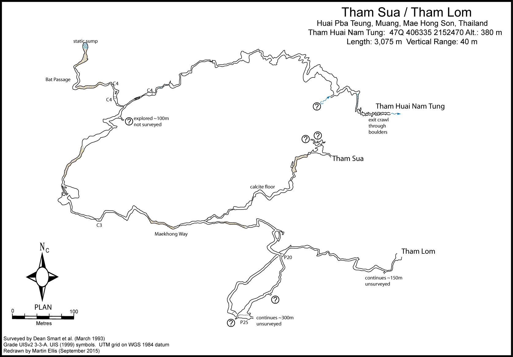
The various entrances to this cave are located 7 km east of the H1095 and 1.5 km west of the Mae Nam Khlong river. From Ban Mae Suriya the track to the Susa Waterfall has recently been upgraded and from the waterfall it is a 1.75 km walk south beside the Mae Nam Khlong before turning west and following the Huai Pba Teung upstream for 1 km to the cave. Tham Huai Pba Teung is at the head of the main tributary stream, while the 3 m diameter entrance to Tham Lom lies behind a pool a few hundred metres downstream from Tham Huai Pba Teung. The Tham Sua Upper and Lower entrances are between Tham Huai Pha Tung and Tham Lom, being a short distance above and 100 m south-west of Tham Huai Pha Tung.
Description
The Tham Sua/Tham Lom system is a complex of caves that collect the water from two streams which are about 1km apart and are both called Huai Kut Pa Tung. The streams sink in dolines, each containing a cave (MH219 'pothole' and Tham Huai Kut Pa Tung). The Tham Sua/Tham Lom system has four entrances: Tham Huai Nam Tung, Tham Lom and the Tham Sua Upper and Lower Entrances. The relationships between the passages in the system are unclear. Tham Huai Nam Tung appears to lie within a high hill at least 500m south of, and trending away, from from the Tham Huai Kut Pa Thung doline and so may once have carried drainage from the MH219 pothole. In Tham Huai Nam Tung the cave starts as a crawl under and through rocks which leads to a chest deep wade. About 100m from the entrance the stream enters on the left side from a low passage that has not been fully pushed. The main, now dry, open walking passage can be followed west and south-west, rising gradually. After about 600m Bat Passage can be followed north-west for 200m to a sump. A short distance further on a narrow canyon, leading to 100m of muddy crawls, has not been fully explored. The passage gradually turns to the east along the Maekhong Way and after 500m a junction leads after 300m to the Tham Sua entrances. After a further 200m and 350m there are two seperate pitches, a P20 and a P25, which connect to Tham Lom. The passage is seen to continue beyond the P25, but has not been explored. At Tham Lom the 3m diameter entrance gives access to an attractive sporting cave which is characterized by phreatic tube passages 3-4m in diameter. The Tham Sua Upper and Lower entrances join via a 10m pitch just inside the cave. From the upper level a very muddy, walking-sized passage, which has not yet been explored, heads towards the low inlet near the entrance in Tham Huai Nam Tung. The lower level trends south-west along some attractively decorated passage, connecting after 300m with Tham Huai Nam Tung.
Topographie
SMART, DEAN (1993) - BCRA Grade 2b SMART, DEAN (1994) - BCRA Grade 2b ELLIS, MARTIN (2009)
Documents
[Topo] MH0061 12/05/2019Bibliography 08/05/2020
- +DILOKWANICH, SITTIPONG; ET AL. (2000) "An Exploration and Database System of the Caves, Mae Hong Son Province" 6 Vols. Faculty of Environment and Resource Studies, Mahidol University, Bangkok - STD649 +Dunkley, John Robert (1985a) "Karst and Caves of the Nam Lang - Nam Khong Region, North Thailand" Helictite Vol. 23 No. 1 pp3-22 +DUNKLEY, JOHN ROBERT (1995) "The Caves of Thailand" Speleological Research Council, Sydney ISBN 0-9589253-9-9 +DUNKLEY, JOHN ROBERT; BRUSH, JOHN B. (ED.) (1986) "Caves of North-west Thailand: Report of the Australian Speleological Expeditions 1983-1986" Speleological Research Council, Sydney ISBN 0-9589253-2-1 +ELLIS, MARTIN (2009) ôThailandÆs Top Twentyö Shepton Mallet Caving Club Journal Series 12 No. 4 pp140-232 +Ellis, Martin (2015c) "Thailand's Longest and Deepest Caves: A Caving Guide" Martin Ellis, Shepton Mallet ISBN 978-1-326-43857-9 84pp +Ellis, Martin; Laumanns, Michael (2017) "Thailand" in Laumanns, Michael; Price, Liz (eds.) (2017) "Atlas of the Great Caves and Karst of Southeast Asia: Part 2 Myanmar - Vietnam" second edition, Berliner Hohlenkundliche Berichte Band 67 pp241-292 +Kiernan, Kevin (1988e) "Geomorphology of a tropical intermontane basin in the Sino-Burman Ranges" 26th International Geographical Congress 1988, International Geological Union, Sydney pp1-24 +Kiernan, Kevin (1991b) "Tropical mountain geomorphology and landscape evolution in North-west Thailand" Zeitschrift f³r Geomorphologie N.F. Vol. 35 No. 2 pp187-206 +SIDISUNTHORN, PINDAR; GARDNER, SIMON; SMART, DEAN (2006) "Caves of Northern Thailand" River Books, Thailand, ISBN 9749863135 +SMART, DEAN (1993) "Tham Seua/Tham Lom" unpublished survey 1:1,000 +SMART, DEAN (1994) "Down and Out in Thailand" Descent No. 119 pp34-36 +SMART, DEAN (1995d) "World Record Stal" Descent No. 125 p19 +SPIES, JOHN (1994) "The Palaces of Darkness" Action Asia (Hong Kong) Vol.3 No.4 pp116-126 +Telling, Jon L. (2002b) "Application to Ghar Parau Foundation" UBSS 2003 Expedition, 10pp
Caves nearby
| Distance (km) | Name | Length (m) | Depth (m) |
|---|---|---|---|
| 0.3 | Coffin Cave MH214 - MH0214 | 50 | 0 |
| 0.8 | Cave MH0219 - MH0219 | 10 | 10 |
| 1.5 | Tham Huai Kut Pba Teung - MH0220 | 278 | 108 |
| 2.2 | Cave MH0157 - MH0157 | ||
| 2.2 | Cave MH0136 - MH0136 | 30 | 0 |
| 2.3 | Tham Susa [MH0059] | 2646 | 0 |
| 2.4 | Cave MH0060 - MH0060 | ||
| 4.6 | Cave MH0113 - MH0113 | 200 | |
| 5.7 | Cave MH0129 - MH0129 |