Tham Pha Daeng - CM0144
19.785192,99.015609
Location
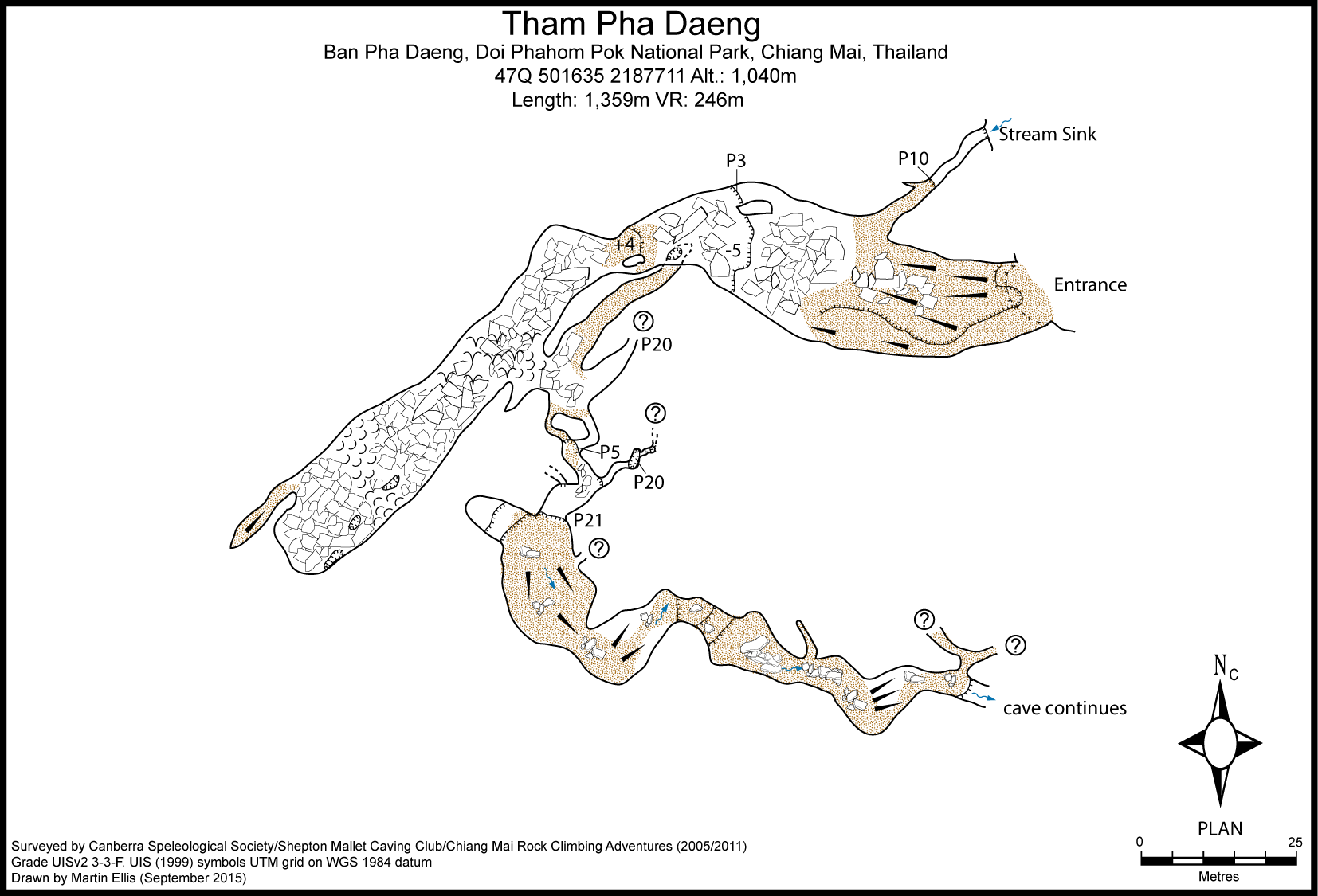
At the northern end of Ban Pha Daeng there is an army checkpoint besides which a track descends down into the large dry valley below the limestone cliff to the north-west of the road. This valley follows a south-west to north-east trending fault and has several stream sinks in it. Following the good dirt track leads to a farm past which you can drive for another couple of hundred metres to a reservoir. You have to walk from here following a good path down into a doline and then follow the seasonal stream bed to the main sink. There is a dry entrance a few metres up on the south side of the stream sink.
Description
The dry entrance descends steeply and is initially descended by following the left hand wall. The passage continues to descend until it reaches a 3m drop on the right hand side. The large passage continues with a couple of routes round and over the boulders where care is required as they are slippery with guano. After about 50 m there is a junction where continuing straight ahead over boulders goes for 50 m to a choke. There are various holes down through the boulders in the floor and this area has not been completely explored. Back at the junction a passage descends to the left and soon reaches two pitches. The left hand 20 m pitch leads to a few hundred metres of passages and chambers. The way on is towards the right were a 5m pitch is descended leading, after a short section of passage, to a 21 m pitch. Before this 'right hand' 21 m pitch there is a narrow rift on the left that has been descended for about 20 m and links with the series of passages reached via the 'left hand' pitch. The P21 is awkward to rig as there is a large ledge 10 m down. From the bottom of the pitch 200 m of streamway ends at a P40 which is soon followed by a magnificent P60. This shaft is circular and the passage enters the shaft part way up - it ascends high above the window. After the big pitch various well decorated side passages are found and the stream is followed along a long narrow canyon to reach the top of a P10. Below the P10 there is a continuation of the narrow canyon which ends at some smaller chambers which are home to hundreds of bats. After going through two bat chambers the passage becomes too tight. Back at the stream way the way on is to take a dry flowstone bypass over a choke. The dry, mud floored passage then continues to a P20. The P20 is awkward with sharp edges and slippery mud. At the base of the pitch the cave ends after 200m where the water disappears and the mud floor hits a vertical wall. An unfinished aid climb has been started in this wall.
Equipement
P3 - on right hand side of entrance passage. Natural belays, rigged with ladder. Pitch can probably be bypassed. P5 - rigged from stal boss high on left hand side (lasso). P21 - bolt installed on left hand side. Holes drilled on right hand side. Ledge at -10m P40 P60 P15 - waterfall pitch P20 - muddy
Hydrology and Geology
In the narrow canyon below the P60 there is a 15cm thick bed of bivalve fossils, similar to the Productus beds seen in Clare, Ireland.
Topographie
Surveyed to the top of the 20 m pitch (-99 m) in March 2005 by SMCC/CSS to Grade UISv2 3-3-F Surveyed to the streamway below the P21 by CMRCA in April 2013 to Grade UISv2 4-3-A
Documents
[Topo] Tham Pha Daeng 05/05/2019Bibliography 29/06/2019
- +Anon. (2015c) "[6th CMRCA Expedition]" www.facebook.com/thailandclimbing 5/9/11 April 2015 +BALICK, MARSHALL (2009) "Fulfilling My Lifelong Dream" 15 January 2009 indulgentadventures.blogspot.com/2009/01/fullfilli… ***Bolger, Terry; Ellis, Martin (2018) "An overview of caves and caving in Thailand" Journal of the Australasian Cave and Karst Management Association No 110 pp32-37 +ELLIS, MARTIN (2005) "Some Caves in Thailand Part 1" Shepton Mallet Caving Club Journal Series 11 No. 7 pp294-321 +Ellis, Martin (2015c) "Thailand's Longest and Deepest Caves: A Caving Guide" Martin Ellis, Shepton Mallet ISBN 978-1-326-43857-9 84pp +Ellis, Martin; Laumanns, Michael (2017) "Thailand" in Laumanns, Michael; Price, Liz (eds.) (2017) "Atlas of the Great Caves and Karst of Southeast Asia: Part 2 Myanmar - Vietnam" second edition, Berliner Hohlenkundliche Berichte Band 67 pp241-292 +HOSIE, PAUL (2009) "Deeper Than Cave Diving û Tham Praduk Puek" Caves Australia No. 180 pp21-23 +HOULE, BRIAN (2013) "Tham Pha Daeng" Product of ND blog 10 April 2013 bhoule187.blogspot.com/2013/04/tham-pha-daeng.html +MORRIS, JOSHUA (2009a) "Managing Real Risk: A Recent Caving Trip" www.thailandclimbing.com/corporate-team-building/m… +MORRIS, JOSHUA (2009b) "Exploring the Unknown" 16 April 2009 www.thailandclimbing.com/corporate-team-building/e…
History
First known exploration was by CSS/SMCC in March 2005 when the cave was surveyed to the top of the 21 m pitch. 2005-03-27 M. Ellis, D. Smart, T. Bolger, N. Anderson 2005-03-28 M. Ellis, D. Smart, T. Bolger, N. Anderson 2009-01 Exploration was continued by Chiang Mai Rock Climbing Adventures - Josh Morris, Marshall Balick, Martin Foakes + 1 who explored to -250 m. 2009-04 J. Morris, J. Spies, P. Hosie, Taw, Kat, Phi, Ben and Ted to a depth of approximately -300 m. The exploration trip lasted 33 hours with the group camping at -240 m. The cave was not surveyed, but was reported as being over 2 km long. 2013-04 CMRCA surveyed the cave to below the P21. 2015-04 On the 6th CMRCA expedition the 13 caver team made an unfinished aid climb at of the vertical wall at the bottom of the cave.
Caves nearby
| Distance (km) | Name | Length (m) | Depth (m) |
|---|---|---|---|
| 3.0 | Phi Man Doi Pha Daeng (Tham) [Phi Man Pha Daeng] [Ruea] [Boat Cave] [CM0271] | ||
| 3.8 | Sink CM0143 - CM0143 | 5 | 4 |
| 4.1 | Ma Phong Sui Tung - CM0100 | 417 | 167 |
| 4.3 | Cave [CM0251] | 200 | 50 |
| 6.6 | Ban Sin Chai Nuea (Sink) [CM0256] | ||
| 6.6 | Sui Tang (Tham) [Elephant Tusk Cave] [Chang Nga Chang] [CM0250] | 800 | 189 |
| 7.9 | Tham Phaya Nak [CM0279] | 40 | 0 |
| 8.5 | Spring BSS 2000-SP2 - CM0107 | ||
| 8.7 | Tham Phra Pikanet [CM0280] | 40 | 0 |