Tham Ban Nam Mut - KA0297
14.571563,98.975566
Location
The cave is on the western shore of the lake in Khuean Srinagarindra National Park. From Ban Nam Mut go through the village and over a stream (which is the water from the cave). After less than 100m, take the second track on the left and follow this until it ends. Left takes you to a small group of houses and back to the stream. Follow this upstream to the resurgence, TF18. Uphill to the right is the entrance to the small cave TF19. Right leads along a footpath which rejoins the track. Follow the track right up the hill to the main cave entrance (TF21).
Description
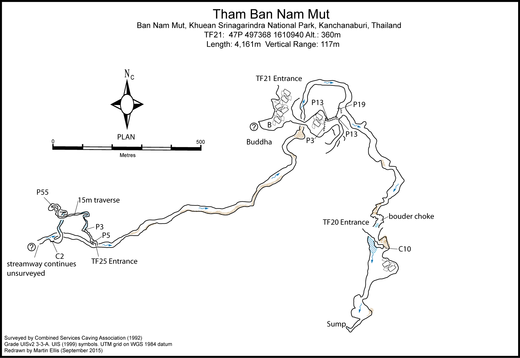
Topographie
Surveyed by CSCA in 1992 to Grade UISv2 3-3-A SMITH, RICHARD J. (ED.) (1995) - BCRA Grade 5. The published survey has a major blunder as the TF25 entrance is west of TF21, not north. ELLIS, MARTIN (2009) - based on the survey in SMITH, RICHARD J. (ED.) (1995)
TF20 is a large collapse entrance which provides only a small entrance hole which drops into a sizeable fossil chamber which requires a 10m handline to assist the climb down to the stream. Downstream sumps quickly while upstream a short swim closes into a complicated boulder choke for 100m before breaking out into the main streamway again. The streamway, which is up to 40m wide in places, can be followed forr 600m before joining with TF21. The streamway was surveyed for a further 2km to where TF25 breaks in on the left. The passage varies in places from wide and high to wide and low, with sporting ducks in several places. The cave continues upstream unsurveyed. TF21 is an immense 80m wide entrance opening into a 180m long fossil chamber which houses a magnificent 15m high Buddha and bamboo bunk beds. Some large stal bosses to the right produce separate smaller chambers. To the left is a fine fossil passage which drops via a fixed ladder and three pitches to the main streamway. The TF25 entrance is a small collapse at the end of a dry sink with a large doline. A climb down through boulders leads to two short pitches which are best laddered. A muddy phreatic passage with static pools leads to a squeeze which shortly ends in a tight rift passage that takes the stream in flood conditions. A traverse above this leads to a further 15m rope traverse and onto a 55m pitch split by a ledge. At the base of the ledge a narrow passage leads into a low water filled passage which is a very unpleasant bat nursery. Beyond this a squeeze through calcite breaks out into the main streamway.
Equipement
P55 from TF25 into the streamway.
Fauna
Isoaedes cavaticus Reinart, 1979 (Arthropoda, Insecta, Diptera, Culicidae) (Reinert 1979)
Documents
[Topo] Tham Ban Nam Mut 28/04/2019Bibliography 05/09/2019
- +ANON. (1992c) "BCRA Conference 1992: Tham Farang" Descent No. 109 p26 +ANON. (1993) "Thailandia û Kanchanaburi" Speleologia No. 28 p97 +Bolger, Terry (1999) "Thailand 1997" Australian Caver No. 148 pp21-26 +COGGAN, MARJORIE; DUNKLEY, JOHN ROBERT; ANDERSON, NEIL (EDS.) (1999) "Tham Sanuk: The Lighter Side Of Caving In Thailand" Canberra, 76pp +DUNKLEY, JOHN ROBERT (1995) "The Caves of Thailand" Speleological Research Council, Sydney ISBN 0-9589253-9-9 +DUNKLEY, JOHN ROBERT (1997) "The Caves of Thailand - Addendum 1995-97" Speleological Research Council, Sydney +ELLIS, MARTIN (2009) ôThailandÆs Top Twentyö Shepton Mallet Caving Club Journal Series 12 No. 4 pp140-232 +Ellis, Martin (2015c) "Thailand's Longest and Deepest Caves: A Caving Guide" Martin Ellis, Shepton Mallet ISBN 978-1-326-43857-9 84pp +Ellis, Martin; Laumanns, Michael (2017) "Thailand" in Laumanns, Michael; Price, Liz (eds.) (2017) "Atlas of the Great Caves and Karst of Southeast Asia: Part 2 Myanmar - Vietnam" second edition, Berliner Hohlenkundliche Berichte Band 67 pp241-292 +HARRISON, B.A.; RATTANARITHIKUL, R.; PEYTON, E.L.; MONGKOLPANYA, K. (1990) "Taxonomic Changes, Revised Occurrence Records, and Notes on the Culicidae of Thailand and Neighbouring Countries" Mosquito Systematics Vol. 22 No. 3 pp196-227 +Kaufmann, Georg (1997) "Thailand 97. Exploration in the National Parks of Thung Salaeng Luang, Thung Saliam, and Sri Nakarind" International Caver No. 21 pp13-18 +KAUFMANN, GEORG; BOLGER, TERRY (1997) "Thailand 1997. Exploration in the National Parks of Thung Salaeng Luang, Tham Chaoram and Sri Nakarind" Canberra Speleological Society Inc. unpublished report for the Royal Forest Department, Bangkok 26pp +NATIONAL PARK OFFICE (2006) "National Parks in Thailand" National Park, Wildlife and Plant Conservation Department, Bangkok 280pp +ROLLAND, IAN (1993) "Cave Exploration In Kanchanaburi - Tham Farang" International Caver No. 9 pp29-32 +ROLLAND, IAN (1994) "Tham Farang" Chelsea Speleological Society Newsletter Vol. 36 No. 1 pp14-17 +SMART, DEAN (1997b) "In The Monks Footsteps" Descent No. 137 p23 +SMART, DEAN (1997c) "The Caving Scene: Thailand" The International Caver No. 20 p43 +SMITH, RICHARD J. (ED.) (1995) "Exercise Tham Farang Thailand 1992 Report" Combined Services Caving Association 49pp +VOGT, NILS B. (2013) "Temple Caves & Grottoes in Thailand: A Picture-Guide Book" Booksmango, Bangkok ISBN 978-616-222-160-6 214pp
History
1992 - The cave was explored by a British expedition, the exploration stopping due to a lack of time with the streamway continuing. It is thought that the water may come from the Huai Tin Phao sink which is 7km and 360m higher. 1997-04 An attempt to continue exploration by a joint Thai/Australian expedition failed to reach the point where the British turned back due to high carbon dioxide. 2010 - Tibor Piroth
Caves nearby
| Distance (km) | Name | Length (m) | Depth (m) |
|---|---|---|---|
| 0.6 | Cave TF19 - KA0394 | 14 | 14 |
| 0.6 | Tham Ban Nam Mut Resurgence - KA0480 | ||
| 1.1 | Tham Phra - KA0168 | ||
| 1.6 | Tham Phra - KA0298 | 200 | 0 |
| 2.1 | Tham Sua - KA0167 | ||
| 4.2 | Neramit (Tham) [KA0163] | ||
| 5.1 | Cave KA0300 - KA0300 | ||
| 5.2 | Sawan (Tham) [KA0492] | 150 | 0 |
| 8.5 | Tham Pisut - KA0495 |