Ma Phong Sui Tung - CM0100
19.816176,99.036524
Location
Ma Phong Sui Tung is located in the large doline south of Ban Luang, below the army camp and checkpoint which is on the road which follows the ridge above. From the checkpoint go a couple of hundred metres north and take the dirt track to the west down to the bottom of the doline. The track continues north along the cultivated bottom of the doline to a farmstead from where it is necessary to go another couple of hundred metres north and then cross the fields to the base of the cliffs at the western edge of the doline. The entrance is a stream sink at the base of the cliff, but on a visit in March 2005 it looked like it had been blocked by a cliff fall.
Description
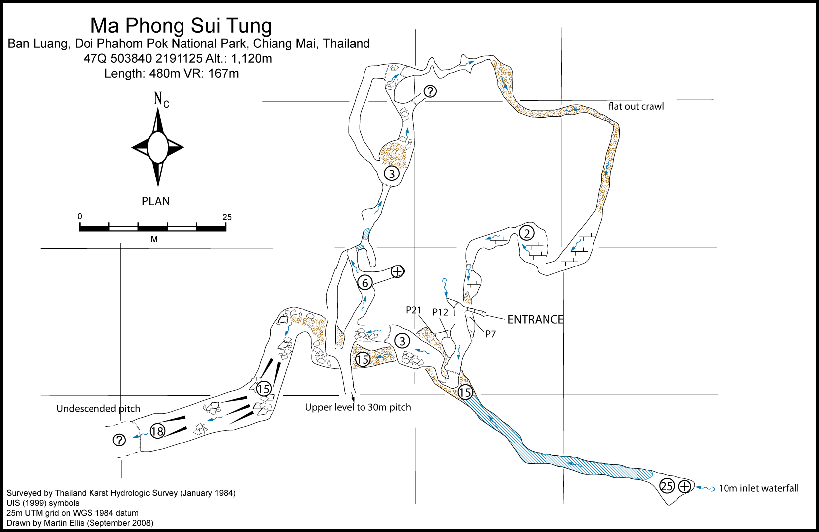
The cave was explored by the Thailand Karst Hydrologic Survey in January 1984 who were stopped by a lack of rope at a depth of 167m. The narrow rift entrance drops down for a few metres before opening up. This entrance series spirals round in a complete circle with a few drops and a couple of oxbows. From one of the oxbows an upper level leads to a 30m pitch that is undescended. After a flat out crawl, the entrance series opens up again and a series of pitches (P7, P12 and P21) lands in the main stream way at a point which is almost directly underneath the entrance. Heading upstream 50m of wading in a high passage leads to a 25m high aven where the stream enters from the top of a 10m waterfall. Downstream the cave descends steeply in a passage which gets wider and higher before exploration was stopped at the top of a pitch.
Topographie
The survey by the 1984 Thailand Karst Hydrologic Survey expedition is to Grade UISv2 3-3-A. ELLIS, MARTIN (2009) from TKHS notes
Documents
[Topo] Ma Phong Sui Tung 04/05/2019Bibliography 26/06/2019
- +ELLIS, MARTIN (2005) "Some Caves in Thailand Part 1" Shepton Mallet Caving Club Journal Series 11 No. 7 pp294-321 +ELLIS, MARTIN (2009) ôThailandÆs Top Twentyö Shepton Mallet Caving Club Journal Series 12 No. 4 pp140-232 +Ellis, Martin (2015c) "Thailand's Longest and Deepest Caves: A Caving Guide" Martin Ellis, Shepton Mallet ISBN 978-1-326-43857-9 84pp +Ellis, Martin; Laumanns, Michael (2017) "Thailand" in Laumanns, Michael; Price, Liz (eds.) (2017) "Atlas of the Great Caves and Karst of Southeast Asia: Part 2 Myanmar - Vietnam" second edition, Berliner Hohlenkundliche Berichte Band 67 pp241-292 +FARRANT, ANDREW; FLOWER, SIMON; LEE, SIMON (2001) "UBSS Expedition to Northern Thailand" University of Bristol Spelaeological Society Proceedings Vol. 22 No. 2 pp125-156 +THAILAND KARST HYDOLOGIC SURVEY (1985) "Doi Chiang Dao & Doi Ang Khang" unpublished notes
Histoire
Explored and surveyed by the Thailand Karst Hydrologic Survey in January 1984. Despite an hour of searchinmg the entrance could not be found in March 2005. In January 2009 the CMRCA team spent 3 hours trying to find the entrance without success.
Cavités proche
| Distance (km) | Nom | Longueur (m) | Profondeur (m) |
|---|---|---|---|
| 0.3 | Cave [CM0251] | 200 | 50 |
| 0.4 | Sink CM0143 - CM0143 | 5 | 4 |
| 4.1 | Tham Pha Daeng - CM0144 | 1359 | 246 |
| 5.4 | Khao Khiri Ket Banphot (Tham) [CM0172] | ||
| 6.6 | Sink CM0147 - CM0147 | ||
| 7.1 | Phi Man Doi Pha Daeng (Tham) [Phi Man Pha Daeng] [Ruea] [Boat Cave] [CM0271] | ||
| 8.1 | Roadside Well Cave - CM0154 | ||
| 8.2 | Black Scorpion Cave [CM0155] | ||
| 8.4 | Poppy Sink Cave - CM0099 | 107 | 93 |