Nam Lei (Tham) [CH00055]
16.573672,101.821173
Location
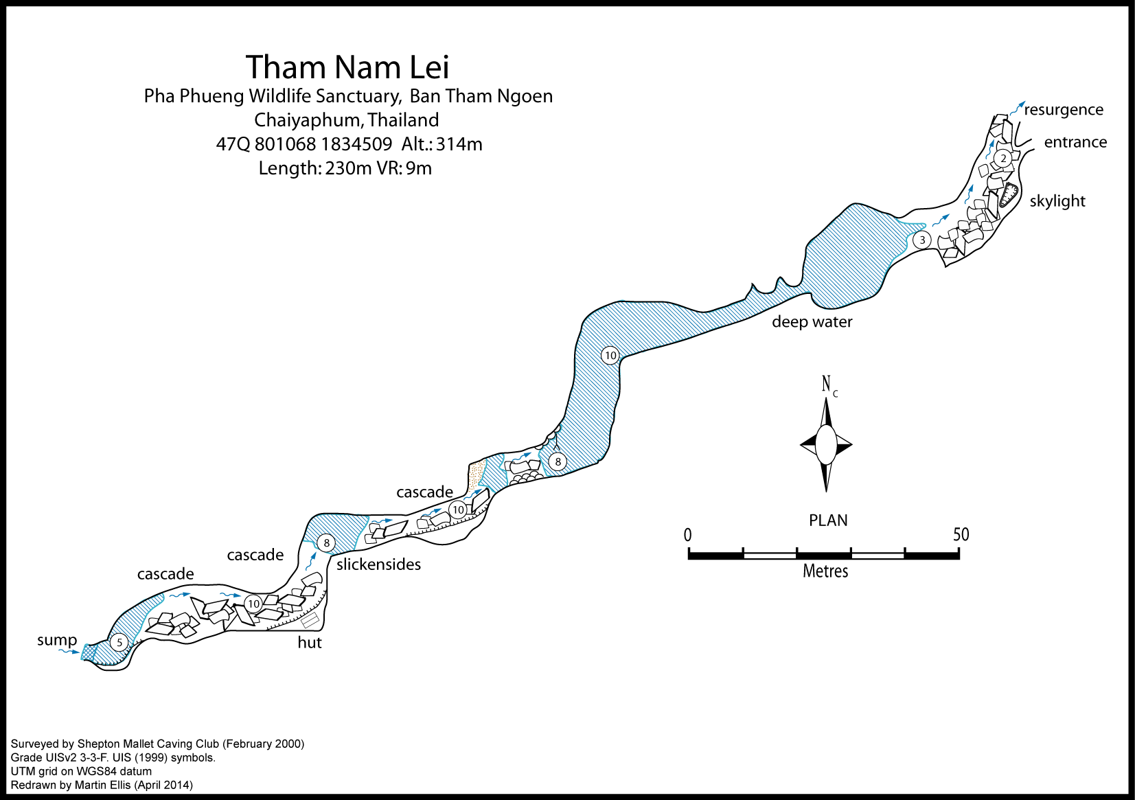
This resurgence is about 1km to the south-west of Ban Tham Ngoen, at the western end of the valley. From the monks house at the head of the valley, a path leads for about 100 meters to the resurgence which is boulder choked. The cave is also signposted in Ban Pha Biat, on the road to Nam Phut Thap Lao, as being 3km away.
Description
Géologie
The cave is formed along a fault. The cave passage mainly follows the strike with cascades where short sections go up dip. Slickensides were seen in the footwall of the fault beside one of the pools.
Topographie
ELLIS, MARTIN; BARRETT, DAVE (2001) - BCRA Grade 3c
Plongée
Upstream sump was dived in November 2010 to a depth of -8m. Difficulty finding the way on due to sloping ledges and silt, but an archway was located.
Fauna
Python reticulatus (Schneider, 1801) (Chordata, Reptilia, Squamata, Pythonidae) (unpublished record)
General description
A hole at the back of the boulders leads down into the boulder floored passage where the stream flows along the right hand wall. After a few metres a skylight is passed and then you reach a landing where the 75m long swim begins. After 20 meters the lake pinches down to a low section which obviously sumps in the rainy season, before the swim opens up again into larger passage. A passage was also noted high up on the left just beyond the low section of the entrance, but the climb will require aid. The lake ends at a gravel beach where there are several large formations. It is possible to walk from here to the upstream sump pool by crossing a sand bar and using large water worn holes in the wall to bypass sections of deeper water. A fine, but short, streamway is followed up several cascades and boulder falls passing a bamboo hut which is used by the monks for meditation. The end of the cave is a 20 meters swim to a low passage which then sumps. In February 2002 the water levels were lower than on the first trip in 2000 enabling a further 10 m of progress at the upstream sump. A calcite slope above the sump may be a potential route over the top. Local monks suggested to Smart in June 1999 that in the dry season this sump can be passed and the cave "continues for over 1 km with no end in sight". In April 2010, after some very dry weather, the sump was still closed and water was resurging.
Documents
[Topo] Tham Nam Lei 28/04/2019Bibliography 21/06/2019
- BARRETT, DAVE (2001) "Shepton Mallet Caving Club Thailand 2002" expedition application form to Ghar Parau Foundation 6pp ELLIS, MARTIN (2010) "Cave Diving Expedition û Central Thailand û November 2010" www.thailandcaves.shepton.org.uk/cave-diving-novem… ELLIS, MARTIN; BARRETT, DAVE (2001) "Thailand Expedition February 2000 Report" Shepton Mallet Caving Club Journal Series 10 No. 8 pp247-272 ELLIS, MARTIN; KING, STEVE; WATERS, ED; BARRETT, DAVE; FITCH, TERENCE (2002) "Thailand 2002 Expedition Report" Shepton Mallet Caving Club Journal Series 11 No. 1 pp1-29 Ellis, Martin; Laumanns, Michael (2017) "Thailand" in Laumanns, Michael; Price, Liz (eds.) (2017) "Atlas of the Great Caves and Karst of Southeast Asia: Part 2 Myanmar - Vietnam" second edition, Berliner Hohlenkundliche Berichte Band 67 pp241-292 FLETCHER, ALEX D. (2011) "Dive Reports: Thailand" Cave Diving Group Newsletter No. 178 January 2011 pp23-24 SMART, DEAN (1999) "Amphoe Khon San, Chaiyaphum" unpublished report. 3pp
Histoire
The cave was surveyed in February 2000 by the SMCC. The upstream sump was dived in November 2010 by Alex Fletcher. 2000-02-21 SMCC (D. Barrett, P. Dummer, M. Ellis, H. Jones) 2000-02-22 SMCC (D. Barrett, P. Dummer, M. Ellis, H. Jones, a monk) 2010-04-21 (M. Ellis, S. Hall, A. Greer, T. Bolger) 2010-11-26 (M. Ellis, A. Sorn-Ek, A. Fletcher, T. Bolger)
Commentaires
Cavités proche
| Distance (km) | Nom | Longueur (m) | Profondeur (m) |
|---|---|---|---|
| 0.3 | Monk Big Chamber Cave [Tham Sing Toh] [CH0054] | 238 | 16 |
| 0.6 | Cave [CH0107] | 20 | 0 |
| 1.0 | Tec (Tham) [CH0052] | ||
| 1.1 | Rock Shelter [CH0051] | 20 | 0 |
| 1.5 | Ban Tham Ngoen Resurgence Cave - CH0008 | 5 | |
| 1.5 | Cave [CH 0102] | 40 | 0 |
| 1.5 | Tham Huang Po [Tham Ban Ngoem] [Tham Wam Bo] [Grotte de la Source] [CH0007] | 250 | 5 |
| 1.5 | Cave CH0006 - CH0006 | 30 | |
| 1.7 | Cave CH0005 - CH0005 |
Fauna
Bats were seen flying in the passage just before the upstream sump. Shrimp and small dark coloured fish were seen in the lake. In April 2010, small pale fish were seen in the pools.
Martin Ellis (21/06/2019)