Tham Nam Tok - KA0361
14.874229,98.858929
Location
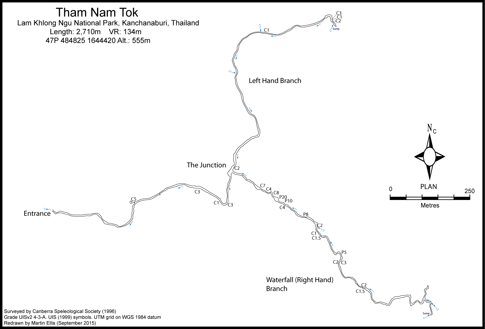
The Nam Khlong Ngu is on the karst plateau to the east of the H323 and good gravel roads give access to the river. After the road crosses a bridge over the Lam Khlong Ngu it ascends to the karst plateau. About 1.5km after the bridge a track on the right can be followed east and then south for about 1km to a parking area. From the parking area head south-east and descend to the river. Follow the river downstream for about 2km to the cave entrance which is 15m east and 5m above the north bank of the Lam Khlong Ngu, 4km upstream of the sink entrance of Tham Nok Nang En. While the low entrance cannot be seen from the river level, its presence is indicated by a tufa cascade on the river bank (note that 500m before the cave entrance there is another set of dry tufa dams above the river).
Description
Hydrology and Geology
Water temperature in Left Hand Branch 24.5¦C April 1996.
The cave has two main streams that join about 800m from the entrance. The Left Hand Branch has more than 800m of passage and ends in a sump above a 3m waterfall. The Right Hand Branch (or Waterfall Passage) has 15 waterfalls more than 1m high along its 1km length and for much of its length the passage is 3-5m wide with the stream extending from wall to wall. Beyond the 1m high entrance the roof rises and is generally two or more metres high although in places there are low crawls and duck-unders resulting from speleothems extending across the passage. The first such place is about 20m from the entrance at The Cows Udders. These are short stalactites 20-30cm in diameter with rounded bottoms from which a number of short straws are growing. In the main passage the stream is mostly walking or wading depth and the several deep pools can be avoided by traversing along the walls. Near The Junction the cave takes a sharp curve left (north) and there are several gravel banks. The main passage has a low gradient falling only 7m in its 800m length and the largest cascade has a vertical drop of about 0.5m. Beyond The Junction a 2m climb past a waterfall leads into the Left Hand Branch which starts as a low, 5m wide passage. The roof height soon increases and most of the passage is at least 2m high with some attractive areas of decoration along the passage. Flowstone cascades occur in several places and at one point flowstone almost completely blocks the passage, leaving just a duck-under. Towards the end of the Left Hand Branch the stream passage splits vertically. An upper level stream cascades down a bedrock and flowstone balcony to join the main stream passage. Some of the water emerges from a tight vertical squeeze that has not been pushed. More water emerges a few metres away from a small tube at the top of a 3m high flowstone cascade. The main stream passage continues under the balcony to a 3m waterfall. This can be climbed, but a dry bypass on the right hand side (looking in) provides easier access to the top of the falls. Disappointingly 20m further on the stream emerges from a sump beneath a huge flowstone cascade. Along its 800m length the Left Hand Branch drops 23m with a total of 6 waterfalls or cascades more than 1m high. The character of the Right Hand Branch (or Waterfall Passage) is quite different to the rest of the cave with a steep gradient and 15 waterfalls or cascades with a total verical drop of 125m in a little over 1km. From The Junction a section of chest deep water in a tall (up to 20m high) narrow passage leads to a cobble beach at the edge of a deep pool. Across the pool is a 7m high waterfall that can be climbed on the right hand side and above this are cascades of 4m then 8m (waterfalls No. 2 & 3), leading to a room at least 14m across. Water extends the full width of the room with the stream entering high on the right hand side (waterfall no. 4). With a height of 20m waterfall no. 4 is the highest found in the cave and it was climbed using a rope and climbing equipment. A bolt and bracket were fixed at the top to allow a safe descent and rope recovery. The next obstacle is a 10m waterfall (no. 5), followed by a deep pool and a 4m cascade. Waterfall no. 7 is 8m high and above this there is a prominent chock stone wedged across the passage and nearby there is a flowstone bridge. Further on there is a 2m waterfall beside a large flowstone bank. A small stream enters near this point, while the passage continues past a duck-under (with 10cm air space) to two small waterfalls (no. 9 & 10) and another low crawl under flowstone. Beyond the crawl several deep pools and some low sections under flowstone there are three more falls within 30m. The first is a 5m cascade followed by falls of 3m and 2m (nos. 11 - 13). Above the falls there is a section of rapids and several cascades about half a metre high and then the final two falls (nos. 14 & 15) which are 2m and 1.5m high respectively. Above the final set of falls the character of the cave changes with the passage having a lower gradient and being generally wider. The roof height varies from less than 1m to 7m, but is generally 2-3m high. The meandering passage gradually reduces in size as the terminal sump is approached. About 70m before the sump is reached a dry stream passage on the left can be followed for about 50m to a mud choke. This passage is heading north and may be coming from Tham Ban Ton Maprow. A considerable amount of vegetable matter is present in the upper reaches of the Right Hand Branch which suggests the stream sink is not too distant. The presence of bats and a definite draught indicate the possibility of an open connection. Tham Nam Tok was explored by the 1996 Canberra Speleological Society expedition.
Archéologie
The DNP website says there are 30 prehistoric paintings of humans and animals on the cave walls.
Topographie
The cave was surveyed by the CSS to Grade UISv2 3-3-A BRUSH, JOHN (1996) - ASF Grade 4.3 SMART, DEAN (1996h) ELLIS, MARTIN (2009)
Documents
[Topo] Tham Nam Tok 28/04/2019Bibliography 17/09/2019
- +ANON. (1996) "Thailand" International Caver No. 18 p40 +ANON. (2009) "Thailand's Top Destinations Vote: Lam Klong Ngu National Park" Bangkok Post Horizons 1 January 2009 +BRUSH, JOHN B. (ED.) (1996) "Khlong Ngu Karst Expedition April 1996. A Report Prepared for the National Parks Division, Royal Forest Department, Thailand" Canberra Speleological Society Inc. iv + 67pp +COGGAN, MARJORIE; DUNKLEY, JOHN ROBERT; ANDERSON, NEIL (EDS.) (1999) "Tham Sanuk: The Lighter Side Of Caving In Thailand" Canberra, 76pp +DUNKLEY, JOHN ROBERT (1997) "The Caves of Thailand - Addendum 1995-97" Speleological Research Council, Sydney +ELLIS, MARTIN (2009) ôThailandÆs Top Twentyö Shepton Mallet Caving Club Journal Series 12 No. 4 pp140-232 +Ellis, Martin (2015c) "Thailand's Longest and Deepest Caves: A Caving Guide" Martin Ellis, Shepton Mallet ISBN 978-1-326-43857-9 84pp +Ellis, Martin; Laumanns, Michael (2017) "Thailand" in Laumanns, Michael; Price, Liz (eds.) (2017) "Atlas of the Great Caves and Karst of Southeast Asia: Part 2 Myanmar - Vietnam" second edition, Berliner Hohlenkundliche Berichte Band 67 pp241-292 +Libralesso, Luca (1997) "Tailandia" Speleologia No. 36 p128 +NATIONAL PARK OFFICE (2006) "National Parks in Thailand" National Park, Wildlife and Plant Conservation Department, Bangkok 280pp +SMART, DEAN (1996h) "Tham Nam Tok Discovery" Descent No. 132 p25
Caves nearby
| Distance (km) | Name | Length (m) | Depth (m) |
|---|---|---|---|
| 0.7 | Double Doline Sinks [KA0381] | ||
| 1.3 | Ban Ton Maprow Stream Sink - KA0380 | ||
| 1.4 | Tham Ton Pan - KA0367 | 200 | 81 |
| 1.6 | Tham Sa Nam - KA0366 | 70 | 60 |
| 1.7 | Tham Ban Ton Maprow - KA0364 | 204 | 0 |
| 1.7 | Camp Stream Sink - KA0382 | ||
| 1.7 | Khang Khao (Tham) [KA0363] | 864 | 0 |
| 1.9 | Tham Hin Lod - KA0362 | 805 | 22 |
| 2.4 | Ban Ton Maprow Stream Rising - KA0379 |