Cyamazera (Ubuvumo)
-1.643611,29.373833
Description
(West province, Virunga mountains, Rubavu district) Co-ordinates: S 01"38°37.0’’; E 029°22'25.8°. Alt. ca. 2,295 m. Explored by the 2004 international expedition to NW Rwanda. Very much branched lava tube cave system with a single entrance in a small roof collapse doline. The cave also has at least three distinctive levels and a number of sub-levels. The cave has some larger chambers and spacious lava tube galleries but often do not provide passages of walking size. Not all the narrow passages were pushed to a final conclusion and at least two crawls with strong air current were left for future exploration. Ubuvumo Cyamazera has very nice lava flow forms in many places. Survey and description according to Laumanns et al. (2005, 2007).
Documents
Ubuvumo Cyamazera 21/11/2015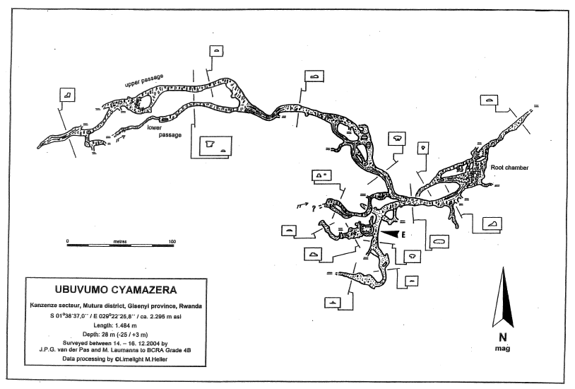
Histoire
Une expédition de trois semaines a été réalisée en février 2007 par le Néerlandais Jan Paul van der Pas et Michael Laummans, dans la région de la chaîne volcanique Virunga au nord-ouest du Rwanda (Afrique centrale), afin de lever les derniers points d’interrogation restants. (cf. Spelunca n°106, 2007, page 4, échos des profondeurs étranger, Rwanda : spelunca.ffspeleo.fr/200706_Spelunca_106.pdf)
Cavités proche
| Distance (km) | Nom | Longueur (m) | Profondeur (m) |
|---|---|---|---|
| 0.7 | Bwibihonga (Ubuvumo) | 4530 | |
| 0.8 | Kabari (Ubuvumo) | 496 | |
| 15.7 | Nyaruhonga 3 (Ubuvumo) | 32 | |
| 20.4 | Manjari 2 (Ubuvumo) [Grotte Mandjari Deux] | 1660 | |
| 25.5 | Nyiragihima (Ubuvumo) | 1116 | |
| 29.4 | Rwego (Ubuvumo) [Grotte des Commandos] | 952 | |
| 30.8 | Musanze - main segment (Ubuvumo bwa) | 1600 | |
| 30.9 | Gacinyiro 2 (Ubuvumo) | 1470 | |
| 31.0 | Gacinyiro 1 (Ubuvumo) | 350 | 25 |