Tham Huai Luk - CM0039
19.536326,99.042418
Location
The Tham Spit swallet entrance is 1.5 km west of the H107 about 2 km south of Ban Tham Klaeb. The River Cave resurgence is near the village of Ban Tham Klaeb at the foot of a limestone outcrop and is partially concealed by large boulders.
Description
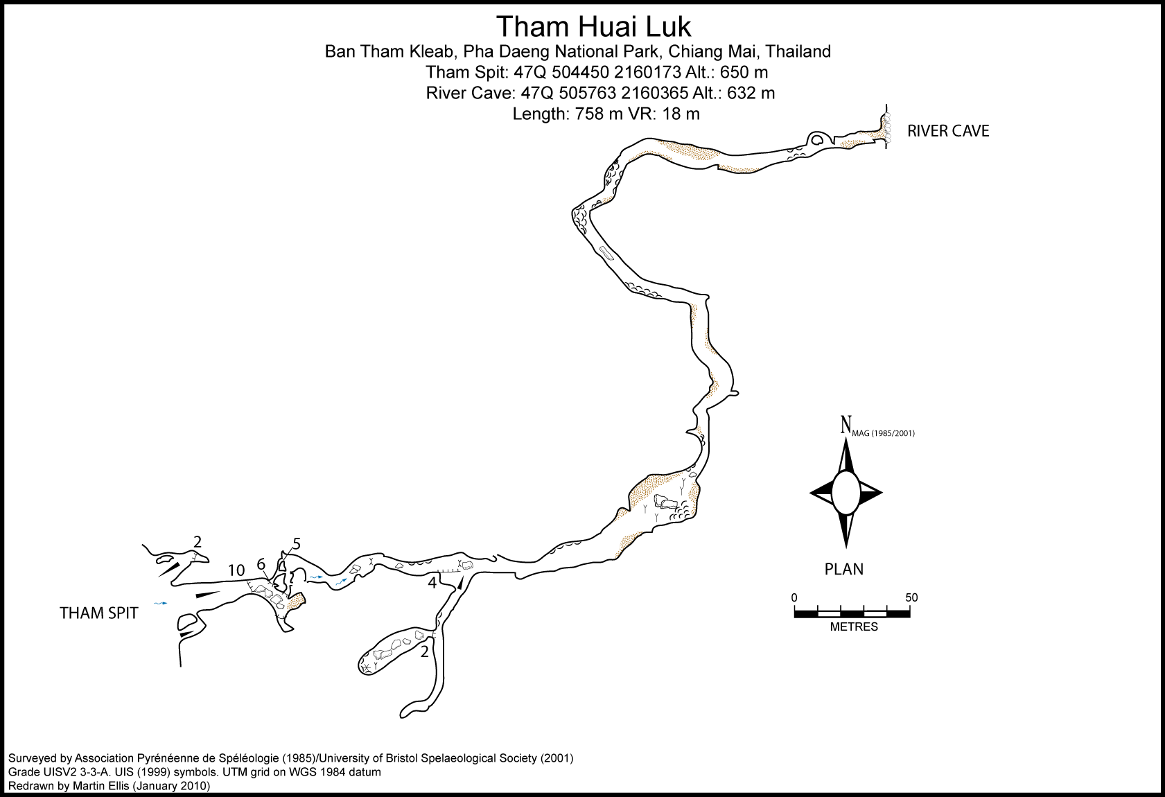
The river sinks at the bottom of a doline into Tham Spit which was explored by the APS in 1985. They explored 60 m of passage to a sump at a depth of 18 m. In 2001 the UBSS explored the River Cave resurgence. This has a 3 m entrance pitch linto a 550 m long stream passage which averages 10-20 m wide and 6-8 m high and is well decorated with flowstone, speleothems and gour pools. The passage terminates in a muddy duck and a sediment choke. Above this choke two high avens can be climbed for 13 m and 15 m to establish separate connections to Tham Spit. Shortly before the terminal choke, a higher level fossil tributary passage can be followed for about 70 m.
Hydrology and Geology
The stream sinking into Tham Spit drains approximately 3 sq km of sandstone hills to the west. From the large number of sizeable logs and bamboo canes, coupled with the large clasts of sandstone on the passage floor, it appears that the streamway takes a large amount of water in flood. It is essentially a single stream passage with the only fossil development related to headward vadose incision and capture close to the stream sink. The cave follows the jointing for part of the distance and near the resurgence the passage is aligned along a small inclined fault. In flood the water backs up at least 4 m behind the entrance boulder choke. Several good sediment sections up to 4 m thick, exhibiting coarse grained cross-bedded sand and gravel can be seen in the middle portion of the cave. At one point in the cave good exposures of a limestone conglomerate can be seen which may be evidence of a Permian or Triassic palaeokarst.
Topographie
DEHARVENG, LOUIS ET AL. (1986) - Grade UISv2 3-3-A - Tham Spit FARRANT, ANDREW; FLOWER, SIMON; LEE, SIMON (2001) - Grade UISv2 3-3-A - Tham Spit / River Cave
Documents
Bibliography 26/06/2019- +DEHARVENG, LOUIS ET AL. (1986) "ExpÚdition Tha´-Maros 85" Association PyrÚnÚenne de SplÚologie, Toulouse ISBN 2-906273-00-7 +DUNKLEY, JOHN ROBERT (1995) "The Caves of Thailand" Speleological Research Council, Sydney ISBN 0-9589253-9-9 +FARRANT, ANDREW; FLOWER, SIMON; LEE, SIMON (2001) "UBSS Expedition to Northern Thailand" University of Bristol Spelaeological Society Proceedings Vol. 22 No. 2 pp125-156
Caves nearby
| Distance (km) | Name | Length (m) | Depth (m) |
|---|---|---|---|
| 0.6 | Cave BSS 2000-12 - CM0136 | 11 | 0 |
| 1.0 | Mud Cave [CM0133] | 30 | 0 |
| 1.2 | Kids' Cave - CM0132 | 151 | 0 |
| 1.3 | Sink BSS 2000-11 - CM0135 | ||
| 3.2 | Tham Klaeb - CM0033 | 176 | 20 |
| 3.3 | Tham Ngung Chang - CM0034 | 50 | 0 |
| 3.7 | Plong (Tham) [CM0176] | ||
| 3.8 | Pang Mo (Shaft) [CM0179] | 5 | 5 |
| 3.8 | Na (Tham) [CM0178] | 50 | 0 |