Nyiragihima (Ubuvumo)
-1.500556,29.553389
Description
(West province, Virunga mountains) Co-ordinates: S 01"30'02.0”; E 029°33'12.2”. Alt. ca. 2,215 m. Explored by the 2004 international expedition to NW Rwanda. Lava tube cave with a single roof collapse doline that serves as entrance. The NW section of the cave is narrow and soon ends with an entrance closed by rocks that is used as a toilet. The SE Section of the cave is spacious, has a clear inclination, and carries a small water stream during the wet season. A boulder choke towards the SE can be by-passed but the cave soon terminates in a narrow crawl that was not pushed seriously and has a strong air current. Thus, the cave could be extended in the future. Ubuvumo Nyiragihima has some loops and parallel passages, all of which re-join the main lava tube. Some remains of a hideout were found in the cave that has no human bones. Survey and description according to Laumanns et al. (2005, 2007).
Documents
Ubuvumo Nyiragihima 21/11/2015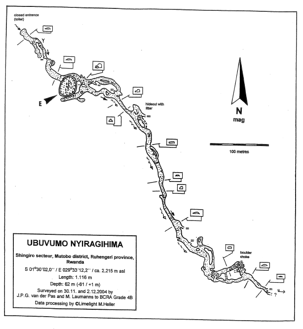
History
Une expédition de trois semaines a été réalisée en février 2007 par le Néerlandais Jan Paul van der Pas et Michael Laummans, dans la région de la chaîne volcanique Virunga au nord-ouest du Rwanda (Afrique centrale), afin de lever les derniers points d’interrogation restants. (cf. Spelunca n°106, 2007, page 4, échos des profondeurs étranger, Rwanda : spelunca.ffspeleo.fr/200706_Spelunca_106.pdf)
Caves nearby
| Distance (km) | Name | Length (m) | Depth (m) |
|---|---|---|---|
| 4.7 | Rwego (Ubuvumo) [Grotte des Commandos] | 952 | |
| 5.5 | Gacinyiro 2 (Ubuvumo) | 1470 | |
| 5.7 | Gacinyiro 1 (Ubuvumo) | 350 | 25 |
| 5.9 | Manjari 2 (Ubuvumo) [Grotte Mandjari Deux] | 1660 | |
| 6.6 | Musanze - main segment (Ubuvumo bwa) | 1600 | |
| 10.2 | Nyaruhonga 3 (Ubuvumo) | 32 | |
| 14.2 | Nyabikuri-Rudi (Ubuvumo) | 3384 | |
| 21.1 | Numatongo (Ubuvumo) | 620 | |
| 24.4 | Gisuvo (Ubuvumo) | 733 |