Nam Lang (Tham) [MH0057] [doublon de #5610, à supprimer]
19.514729,98.137909
Location
Tham Nam Lang is 3km southeast of the Nam Khong bridge on the H1095 road. Traditionally the route to the cave involved following the path down the river from behind the Royal Forest Department station, crossing and recrossing the river several times before reaching the junction between the Nam Khlong and Nam Lang rivers. However, since the track to the Susa waterfall has been upgraded a shorter walk in can me made from this track where it reaches the Nam Khong river for the first time at 47Q 408100 2157150. A foot suspension bridge crosses the river and then the path ascends to a ridge which is followed eastwards for 775 m, then north-east and then east for 500 m to the cliff line. The cliff is followed north for 500 m to the cave entrance which is at the base of enormous cliffs, at the top of a long pile of boulders above the stream resurgence.
Description
The entrance chamber, 50 m wide, 30 to 40 m high and 80 m long, has a large boulder slope that descends down to the river. The river passage can be followed upstream to the limit of daylight over 200 m into the cave. A climb is then soon required over a flowstone barrier and gours nearly 60 m wide. The stream is then regained and can be followed continuously for 5 km and then intermittently for another 1.6 km. The streamway is very constant in width being 10 to 20 m wide. The roof heights have been estimated at never less than 10 m, usually over 20 m and sometimes reaching 80 to 100 m and in places the line of sight reaches 200 m. For the first kilometre the cave is strike controlled. In the first 3 km the floor is occasionally bedrock, but is usually meandering stream channel between sand and gravel banks. There are regular rockfalls up to 6 to 8 m high and a few hundred metres long. Between 3 and 6 km from the entrance there are long stretches of slow moving water up to 1.5 m deep with large deposits of mud. Near the 5 km mark the cave shows signs of flooding to the roof. At the upstream end of this area the cave briefly narrows and the ceiling drops to within a few metres of the water before opening up again. Large expanses of flowstone and gours are found 0.3 km (Tham Khang Khao) and 1.3 km (Phra Racha Wang Mekhala) from the entrance forming ramps up to 10 m above the stream. Both flows are formed by small seasonal inlets. Several other similar inlets occur, most of which close down after about 50 m though one near the 5 km mark can be followed southwards for 255 m. The extensive, unstable, rockfalls suggest that the cave has higher levels. The first rockfall is 1.1 km into the cave and has not been thoroughly explored, but has been climbed to a height of about 50 m. The second rockfall, Doi Hin Yai, is 1.8 km into the cave. This rockfall is 120 m long, 80 m wide and from the top, at 50 m, a large shaft (Ban Khong Ramasura) extends upwards beyond the limit of caving lights. The trickle of water and fresh vegetation suggest a connection with the surface which is about 300 m above. The most extensive upper level series is the Tham Ban Khong Kwan series. This starts with a steep rubble slope just before the 4 km mark. From a trunk passage about 50 m above the stream a chamber to the east gives access to at least one large passage that ends at an undescended 25 m pitch that draughts strongly. From the downstream end of the trunk passage a very well decorated and large chamber (Sala Khan Thai) leads off to the left. At the western end of the chamber there is an estimated 30 m pitch back into the streamway while at the other end a muddy passage 5 m in diameter leads to a small inlet (Huai Khwae Noi) which sumps at both ends. Back in the main streamway, from the boulder slope up to Tham Ban Khong Kwan, the stream passage continues with gravel banks. The deep water shallows at a point beneath a huge fissure ascending up into the roof which has a rockfall below and a large chockstone wedged across the rift 10 m above the floor. Deeper pools are then met in the streamway until a rockfall is reached which blocks the full width of the passage. 10 m above the stream a dry bypass starts. This bypass passage is 20 m wide by 20 m high. At the upstream end of the dry bypass there are sandy banks. This area has been used as a campsite to explore the far reaches of the cave. Upstream of the campsite the stream passage continues to a flat, gravel floored, section where the 255 m long inlet comes in from the south. Beyond this inlet the stream passage reaches a bench (another possible campsite), an area of columns on the left and a large flowstone which overhangs the stream. This is the start of a deep, swift flowing section known as King Khlong. The passage is 6 m wide and 15 m high with sharply scalloped bedrock floor and walls. However, ledges above the stream help with crossing this area. The stream makes a 90¦ bend (where there is a possible side passage) then widens to 30 m and the roof rises to 30 m. The next section has rockfalls across the stream in two places and widens further to 15 m with large columns on the right (where, again, there may be an upper level). Beyond here the streamway narrows and increases in gradient with several rapids. After 250 m there is a rockfall of large boulders which is nicely decorated with a large stalagmite. Descending the far side of the rockfall regains the stream, but it emerges from another rockfall on 30 m further on. This rockfall is in a very high rift and the boulders have been climbed without reaching the top of the roof. This boulder choke is very unstable. Towards the east the rockfall leads to a section of decorated upper level with several descents between the boulders back to the stream. After a short section in the rocks a solid stream passage was reached, about 6 m wide and 4 m high. After 80 m this ended at a deep pool with a 0.5 m waterfall on the far side where the stream comes out of a slot 0.6 m wide. This obstacle has been passed to reach another 30 m of stream passage to a point where the stream emerges from beneath a 4 m high boulder. To the left a boulder slope has not been pushed. At this furthest point it is only about 500 m to the sink of the Nam Lang river.
Topographie
The cave was surveyed by the Australian expeditions in 1984 (to 3.5 km), 1985 (stream passage and upper level to total length of 6.7 km, with a 130 m long measuring rope and legs up to 200 m!). 1986 (to the terminal choke) and 1988 (upper levels to a 25 m pitch). The location of the survey notes is unknown. Published surveys: DUNKLEY, JOHN ROBERT (1985) - ASF Grade 4.3 DUNKLEY, JOHN ROBERT; BRUSH, JOHN B. (ED.) (1986) BOLAND, KEN (1992b) ELLIS, MARTIN (2009) - based on survey in DUNKLEY, JOHN ROBERT; BRUSH, JOHN B. (ED.) (1986) SIDISUNTHORN, PINDAR; GARDNER, SIMON; SMART, DEAN (2006) Ellis, Martin; Laumanns, Michael (2017)
Fauna
Paratachycines (Paratachycines) thailandensis Gorochov, 2002 (Arthropoda, Insecta, Orthoptera, Rhaphidophoroidea, Raphidophoridae) û type locality (Gorochov 2002) Schistura oedipus (Kottelat, 1988) (Chordata, Actinopterygii, Cypriniformes, Balitoridae) û type locality (Kottelat 1988)
Documents
[Topo] Tham Nam Lang 12/05/2019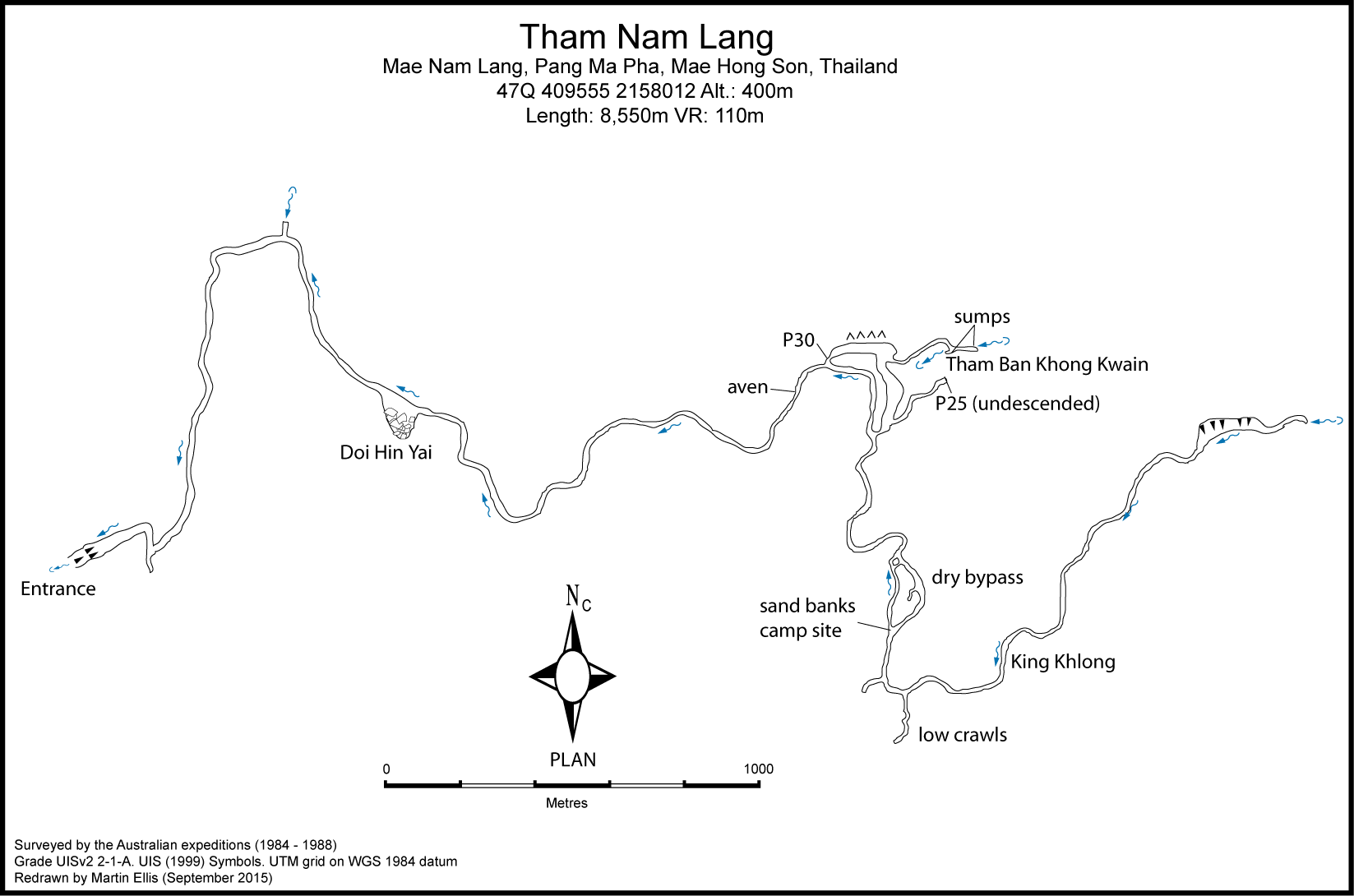
Histoire
Despite its size Tham Nam Lang was apparently not well known locally, being about 4km from the nearest village and 1984-01 first recorded visit beyond the spectacular entrance chamber was by the Australians Further exploration occuring on the 1984, 1985, 1986 and 1988 Australian expeditions, since when only minor advances have been made. 1988 J. Brush, N. Anderson - descended pitch in upper series to 100 m of passage to sump. 2018 R. Gardner 2019-03-02 J. Brush, N. Anderson, M. Coggan
Cavités proche
| Distance (km) | Nom | Longueur (m) | Profondeur (m) |
|---|---|---|---|
| 0.0 | Nam Lang (Tham) [MH0057] | 8550 | 110 |
| 0.4 | Pha Nam Lang (Tham) [MH0058] | 20 | 0 |
| 0.6 | Pha Tao Daeng Overhang [MH0270] | ||
| 1.7 | Cave MH0204 - MH0204 | ||
| 1.7 | Coffin Cave MH205 - MH0205 | ||
| 1.8 | Cave MH0113 - MH0113 | 200 | |
| 2.5 | Tham Sa Tho - MH0135 | ||
| 2.8 | Tham Yin Lee Nan Nam - MH0230 | ||
| 3.0 | Nam Bor Phi - MH0017 | 106 | 106 |