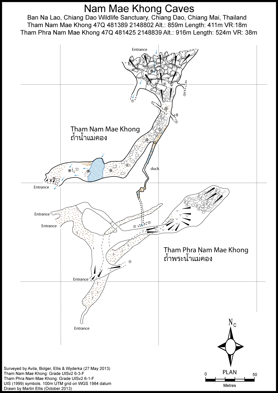
Nam Mae Khong (Tham) [CM0253]
19.433482,98.822709
Location
The Nam Mae Khong river and Huai Mae Khong stream join and then sink in a doline 3 km west-north-west of Ban Na Lao. From the Lisu village of Ban Na Lao take the motorbike track through the fields. Where the track ends a foopath starts that crosses a fence into the Chiang Dao Wildlife Sanctuary. The path follows the river downstream, often having to take the river bed as there is no path on the bank. The path is well worn and obvious and eventually reaches the river coming from the cave. Follow this river upstream until you meet a larger path which goes between the river and the monk's dwelling in the cliff above. Take the path downhill, cross the footbridge and walk for a few metres to the large resurgence entrance.
Description
General description
From the resurgence entrance it is necessary to wade across a pool to a flood overflow passage with the main stream comes out of the boulders on the left. The large overflow passage is dry, rocky and is 15m wide by 15m high and after about 150m you reach the very large collapse of the sink entrance. The sink entrance is in a doline 100m in diameter and 100m deep and the ascent out of it is difficult. On the true right hand side of the collapse entrance the main river descends steeply amongst boulders to a couple of chambers and the water route has not been pushed downstream. Halfway through the overflow passage there is a small, fault controlled stream passage on the true left hand side. After 100m this becomes a flat out crawl which has been explored for 40m to a T junction where a stream flows from left to right. This side stream is heading away from the main resurgence.
Survey
Ellis, Martin (2015a) Grade UISv2 6-3-F - Ellis et al. May 2013 - main passage and part of parallel stream passage.
Documents
[Topo] Tham Nam Mae Khong 05/05/2019Bibliography 06/07/2019
- Ellis, Martin (2015a) "Some caves in Thailand Part 4" Shepton Mallet Caving Club Journal Series 13 No. 3 pp91-118 Gosset, John (2015b) "ExpÚdition DAO 2015 (suite et fin)" l'Equipe SpÚlÚo de Bruxelles blog 3 April 2015 esbhotnews.blogspot.co.uk/2015/04/expedition-dao-2… Gosset, John (2016a) "Dao 2015 ExpÚ Tha´lande" Regards No. 81 pp76-95
Cavités proche
| Distance (km) | Nom | Longueur (m) | Profondeur (m) |
|---|---|---|---|
| 0.1 | Phra Nam Mae Khong (Tham) [CM0276] | 524 | 38 |
| 0.2 | Cave CM0275 | ||
| 2.7 | Tham Mae Pla Ao [Mai Pas Ao Resurgence Cave} [Tham Ban Oui Haen] [Mai Pla Sao] [CM0019] | 1762 | 37 |
| 3.0 | Ban Fa Suai Rockshelter [CM0238] | 15 | 0 |
| 3.1 | Cave CM0183 - CM0183 | ||
| 3.1 | Bae Bet (Tham) [Perte de Ban Na Lao] [CM0008] | 40 | 7 |
| 3.3 | Cave CM0182 - CM0182 | ||
| 3.4 | Cave CHD05 - CM0009 | 15 | 8 |
| 4.9 | Cave PL24 - CM0224 |