Tham Luk Kae - LA0067
19.111829,99.576332
Location
From Wang Nuea take the H1035 road south for 3.5 km to Ban Huai Khoi where Tham Phra Ngam is inconspicuously signed in Thai to the west. The side road leads to Ban Mae Phrik with occasional signs to Tham Phra Ngam. From Ban Mae Phrik head westwards and continue where the sealed road becomes a dirt track and reach Wat Tham Phra Ngam. Turn left at the gate to the wat, back onto a dirt track and follow this up the valley to the national park ranger station. A couple of hundred metres before the wooden bridge into the ranger station Tham Luk Kae is signposted as being 100 m to the north of the track.
Description
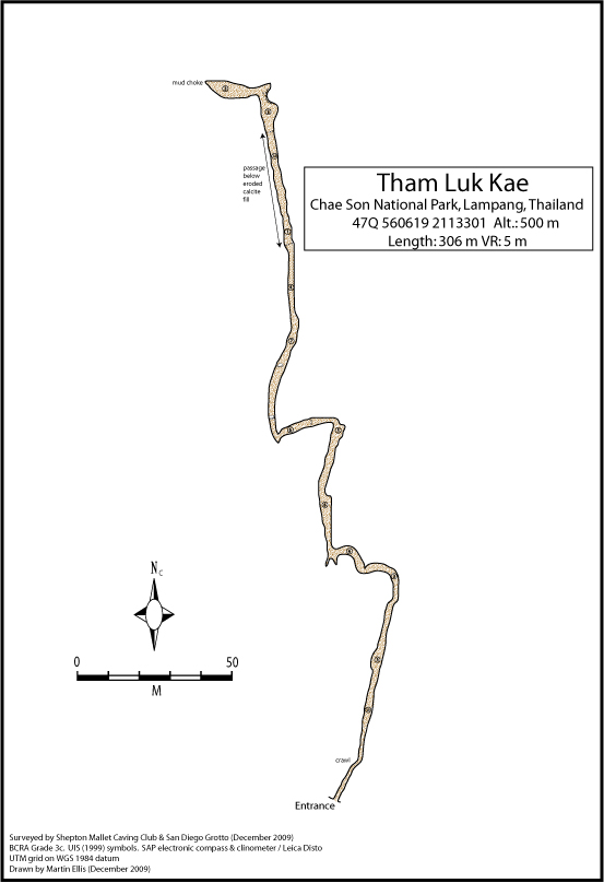
The cave consists of a single sub-horizontal fossil passage. The floor is mainly dry and dusty mud and in some sections the cave has been filled with massive flowstone which reduces the passage to a stooping height.
Topographie
ELLIS (2013a) - BCRA Grade 3c
Documents
[Topo] Tham Luk Kae 30/04/2019Bibliography 06/12/2019
- ELLIS, MARTIN (2013a) "Some Caves in Thailand Part 3" Shepton Mallet Caving Club Journal Series 12 No. 10 pp554-578
Cavités proche
| Distance (km) | Nom | Longueur (m) | Profondeur (m) |
|---|---|---|---|
| 0.5 | Mor (Tham) [LA0065] | 106 | |
| 0.8 | Luang (Tham) [LA0066] | 226 | 8 |
| 0.9 | Tham Pha Ngam - LA0054 | 1578 | 41 |
| 2.1 | Sink LA0082 | ||
| 3.3 | Sink LA0083 | ||
| 13.2 | Ban Pong Tham - LA0019 | ||
| 23.5 | Tham Pha Cho - LA0048 | 75 | 5 |
| 27.4 | Ban Pa Kha Sink [LA0078] | ||
| 38.2 | Tham Nang Phaya Pang Din Fai - LA0049 |