Din (Tham)
19.873167,102.078060
Location
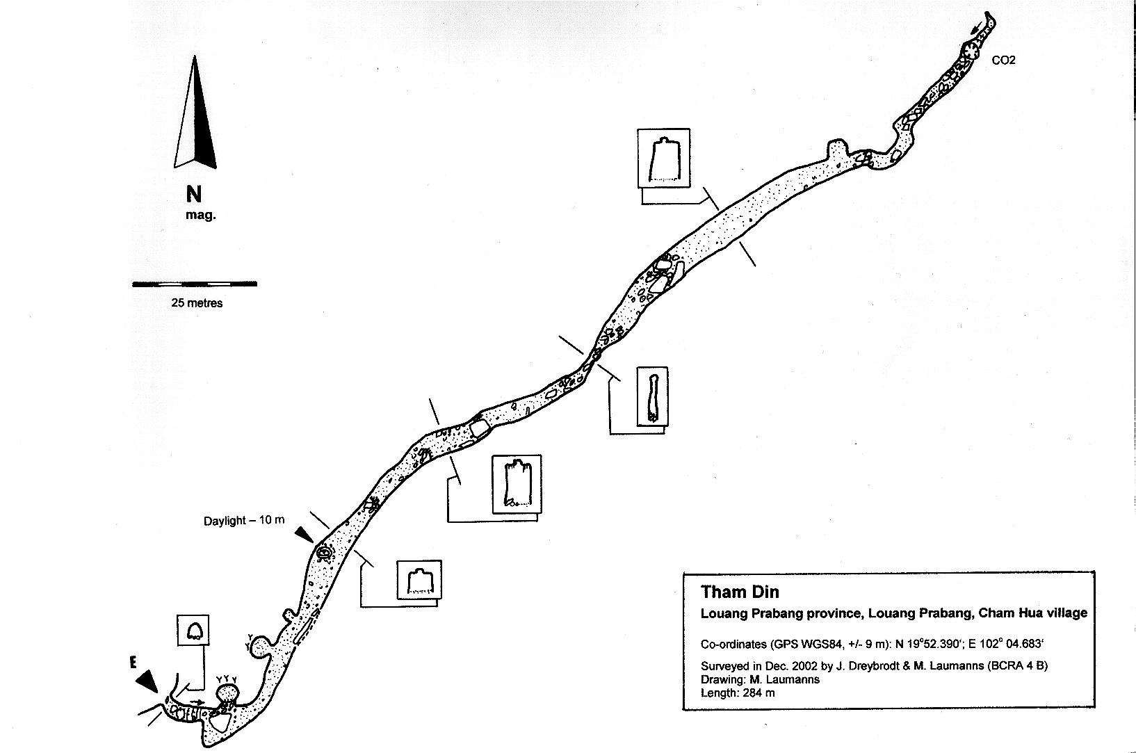
Chomngoua village is situated 6 km west of Luang Phrabang on the south side of the Mekong. A path leaves the village north of the monastery. A smaller footpath branches off to the right after 50m and steeply ascends almost to the top of the hill. The 3 m x 2 m wide entrance is situated above a field about two thirds up the hill and 15 minutes from the village [5158] Map sheet: E48-001 Methode: GPS
Description
DREYBRODT JOERG informations
Cave description: ? Citation: ? Analysis: [5158]: The climbable entrance leads steeply down to the well-sized 280 m long main passage that runs SW-NE. With the exception of two round-shaped rooms near the entrance that have rich calcite decorations and a few remains of small wooden Buddha statues, the main passage is unbranched. A small skylight intersects the roof of the gallery approxi-mately 60 m from the entrance. The cross-section of the fossil gallery is rectangular and very pronounced, especially in the rear part of a few remains of small wooden Buddha statues, the main passage is unbranched. A tube is visible on the ceiling for almost the complete length of the cave. Breakdown occasionally piles up in the passage. The end of the cave is marked by a 7-10 m deep pit with remains of a bamboo ladder. High CO2 content in the air prevented an attempt at descent. Tham Din is interpreted to be a former sinkhole with a subsequent underground drainage to the Mekong. The cave is sometimes visited by tourists on guided outdoor trips, although it requires moderate climbing over slippery boulder. >> survey >> shown on map Equipment: High CO2 content in the air of the terminal pit. The cave requires moderate climbing over slippery boulder [5158] Remarks: No. 5 in map Jörg Dreybrodt, References: [4846]: Dreybrodt, J. & Laumanns, M. 2003: Der unbekannte Norden von Laos - Ergebnisse eines Erkundungsprojekts. Mitt. Verb. Dt. Höhlen- und Karstforsch. 49 (2): 38-41. [4847]: Dreybrodt, J. & Laumanns, M. 2003: Northern Laos Christmas 2002. Expedition to Muang Ngoy & Luang Prabang, Lao PDR. Unpublished Report, 20pp. [5158]: Dreybrodt, J. & Laumanns, M. (eds.) 2005: The unknown North of Laos (Karst and Caves of the Provinces Luang Phrabang and Luang Nam Tha). Berliner Höhlenkundliche Berichte 16. 105 pp & Annex.
Histoire
Two round-shaped rooms near the entrance have a few remains of small wooden Buddha statues, At the end of the cave is a pit with remains of a bamboo ladder. The cave is sometimes visited by tourists on guided outdoor trips, although it requires moderate climbing over slippery boulder [5158] Explo history: Dec. 2002 explored & surveyed to 284 m by Dreybrodt & Laumanns/ German Lao Speleological Project 2002/2003 [5158]
Cavités proche
| Distance (km) | Nom | Longueur (m) | Profondeur (m) |
|---|---|---|---|
| 1.3 | Tatkeh (Tham) | 0 | |
| 1.3 | Tatkeh 2 (Tham) | 0 | |
| 1.3 | Tatkeh 3 (Tham) | 0 | |
| 6.4 | Phousi (Tham) | 0 | |
| 7.1 | Dok Boa (Tham) | 0 | |
| 7.1 | Kok Mu (Tham) | 29 | |
| 7.3 | Khou Ha Sackalin (Tham) | 0 | |
| 7.5 | Luang (Tham) | 0 | |
| 7.9 | Thiep (Tham) | 0 |