Tham Huai Bon (Wat) - CM0032
19.984819,99.184074
Location
The temple is 10 km north-west of Fang, near the eastern edge of the Doi Phahom Pok National Park and close to the 4WD track leading to Doi Phahom Pak. From the Fang by-pass take the road signposted to Ban Huai Mayom which turns into a dirt track after a few kilometres. About 6 km from the ring road turn left just after the border of the national park. The cave is halfway up the cliffs at the back of the temple comples, reached by a steep staircase.
Description
The rock shelter is 40 m x 20 m. It is divided into two sections by a natural rock pillar with a gilded Buddha in an alcove behind. The right section contains sleeping platforms made of wood from coffins, a potent reminder of the immanence of death. The message is further reinforced by macabre wall paintings of a skeleton and of the Hand of Awareness. The association with death probably comes from the deep layer of animal bones embedded in the floor sediments. The shelter appears to be a prehistoric site as pottery and other artifacts can be seen along with the bones.
Documents
Tham Huai Bon (Wat) 05/05/2019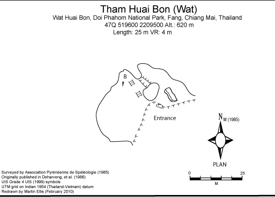
Histoire
Tham Huai Bon (Wat) was visited and surveyed by the APS in 1985.
Cavités proche
| Distance (km) | Nom | Longueur (m) | Profondeur (m) |
|---|---|---|---|
| 0.3 | Tham Huai Bon (Haeng) [Tham Raud Tira] [Tham Haeng] [CM0138] | 535 | 48 |
| 10.2 | Tham Huai Bon (Nam) - CM0145 | 200 | 0 |
| 16.7 | Cricket Cave [CM0150] | 347 | 106 |
| 17.0 | Ang Khang (Sinkhole) [CM0245] | ||
| 17.1 | Sink CM0159 - CM0159 | ||
| 17.2 | Tham Hub Pha Khao - CM0158 | ||
| 17.3 | Dead Robber Waterfall Cave [CM0097] | 570 | 166 |
| 17.4 | Tham Ban Luang - CM0074 | 590 | 199 |
| 19.0 | Black Scorpion Cave [CM0155] |