Tham Huai Kun - MH0077
19.659950,98.198183
Location
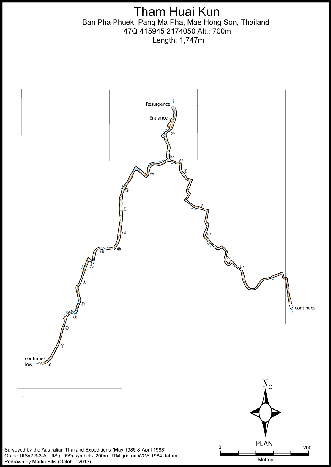
A resurgence about 2.5km north-west of Ban Pha Puek on the south side of the Huai Nam Pung. From Ban Pha Phuek a good dirt track leads through the fields to the west of the village to a ford on the Huai Nam Pung, passing very close to the entrance. The valley below the cave is cultivated for rice.
Description
A perennial stream discharges from talus about 100m above the East Huai, forming an extensive series of small travertine cascades. Beyond the talus a comfortable sized streamway 4-6m high and wide, floored by fine gravel and sand with very little breakdown extends southwards. After about 100m this splits into two passages of similar dimensions to the entrance passage. The eastern branch trends south-eastwards and contained little running water at the time of exploration. After a few hundred metres there are two low crawls and then the passage resumes its spacious size. Exploration continued beyond a series of tight Z-bends. The end was not reached in 1986. The western branch trends roughly south-westwards with some minor temporary deflections to the west, but in some areas exhibiting little change in direction whatsoever as it runs along the strike for hundreds of metres. The roof gradually dropped lower towards the furthest point reached (in 1986) where a rapid could be heard beyond a crawl 0.3-0.4m high and 8m wide.
Topographie
The cave Western Branch and part of the Eastern Branch was surveyed by the 1986 Australian expedition. The Eastern Branch was surveyed on 22 April 1988 by the Australian expedition and this survey data (without sketch) is extant (courtesy of John Dunkley). DUNKLEY, JOHN ROBERT; BRUSH, JOHN B. (ED.) (1986) - ASF Grade 4.2 (Grade UISv2 3-3-A). KIERNAN, KEVIN (1990) - based on DUNKLEY, JOHN ROBERT; BRUSH, JOHN B. (ED.) (1986)
Documents
[Topo] Tham Huai Kun 11/05/2019Bibliography 09/05/2020
- +COGGAN, MARJORIE; DUNKLEY, JOHN ROBERT; ANDERSON, NEIL (EDS.) (1999) "Tham Sanuk: The Lighter Side Of Caving In Thailand" Canberra, 76pp +DUNKLEY, JOHN ROBERT (1995) "The Caves of Thailand" Speleological Research Council, Sydney ISBN 0-9589253-9-9 +DUNKLEY, JOHN ROBERT; BRUSH, JOHN B. (ED.) (1986) "Caves of North-west Thailand: Report of the Australian Speleological Expeditions 1983-1986" Speleological Research Council, Sydney ISBN 0-9589253-2-1 62pp +Kiernan, Kevin (1988e) "Geomorphology of a tropical intermontane basin in the Sino-Burman Ranges" 26th International Geographical Congress 1988, International Geological Union, Sydney pp1-24 +KIERNAN, KEVIN (1990) "Some Limestone Caves North-east of Mae Hong Son, Northern Thailand" Natural History Bulletin of the Siam Society Vol. 38 No. 1 pp59-67 +Kiernan, Kevin (1991a) "Geomorphological evidence for Quarternary climatic change in the Lower Sino-Burman Ranges" Singapore Journal of Tropical Geography Vol. 12 No. 2 pp112-123 +Kiernan, Kevin (1991b) "Tropical mountain geomorphology and landscape evolution in North-west Thailand" Zeitschrift f³r Geomorphologie N.F. Vol. 35 No. 2 pp187-206
History
The cave was first explored by the 1986 Australian expedition when the south-west branch was surveyed. The east branch was surveyed in 1988.
Caves nearby
| Distance (km) | Name | Length (m) | Depth (m) |
|---|---|---|---|
| 1.7 | Tham Pi Man Pang Kham West - MH0078 | 200 | 0 |
| 1.8 | Tham Pi Man Pang Kham East - MH0268 | ||
| 2.0 | Tham Pha Puek - MH0076 | 680 | 166 |
| 2.0 | Coffin Cave MH0079 - MH0079 | ||
| 2.0 | Coffin Cave MH170 - MH0170 | ||
| 2.1 | Tham Pang Kham - MH0074 | 1370 | 75 |
| 2.2 | Sink MH0309 | ||
| 2.2 | Coffin Cave MH169 - MH0169 | ||
| 2.5 | Cave MH0171 - MH0171 |