Doun (Tham) [Ban Pathém]
20.665611,102.642560
Location
Tham Doun can be reached by foot from the village of Sop Kan in about 30 minutes. Follow the road towards the school, which is located at the southern end of the village. After about 25 minutes of walking, leave the path and travel through a riverbed in an upstream direction to the entrance of the cave from which a streamlet emerges [5158] Map sheet: F48-122 Methode: GPS
Description
DREYBRODT JOERG informations
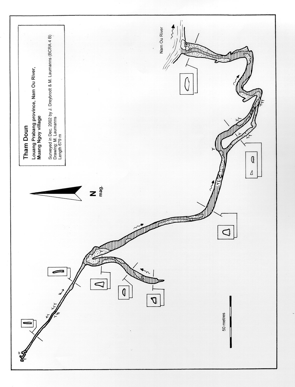
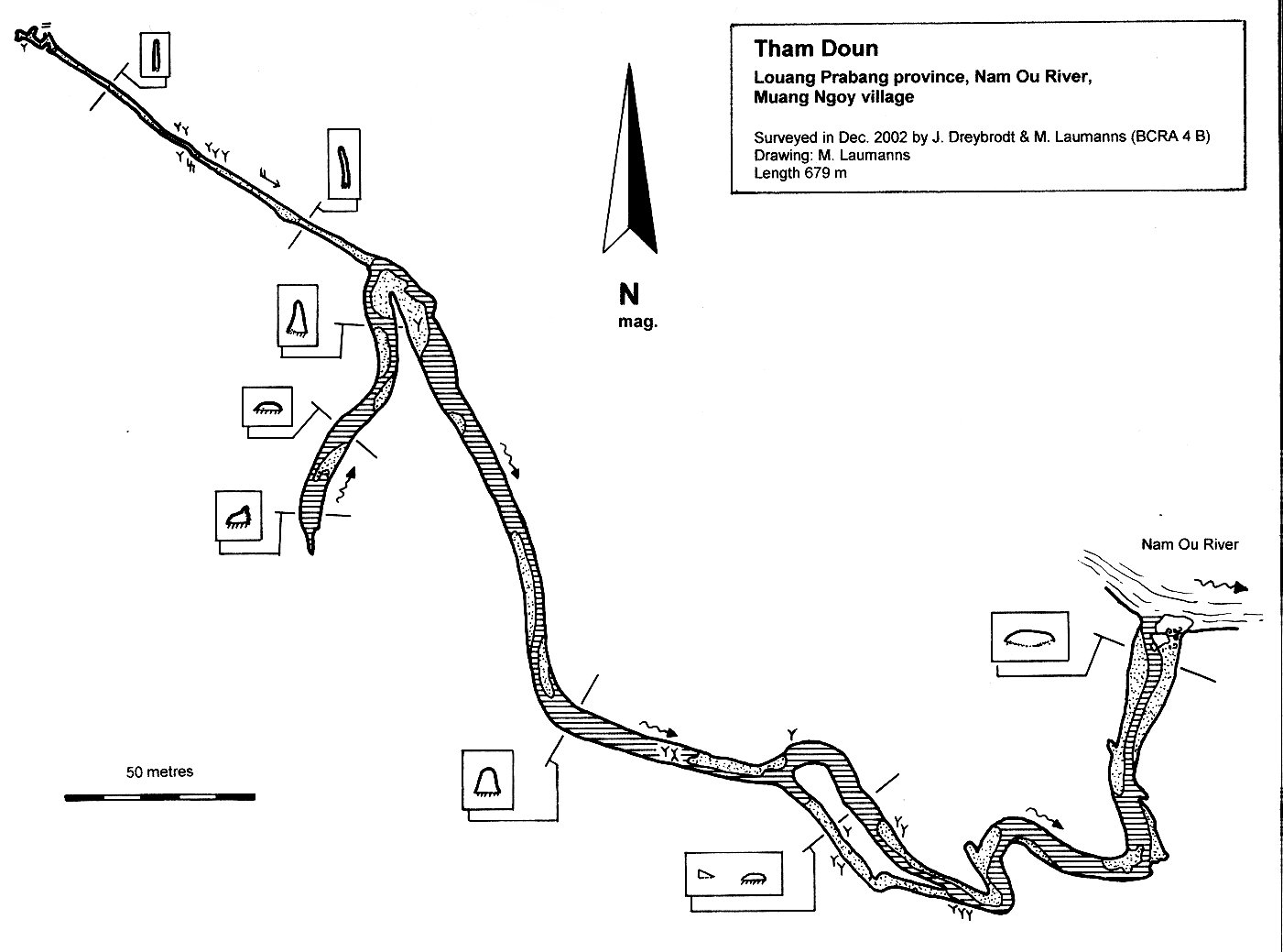
History:The locals have known about the cave for generations and used it as a shelter during the Vietnam War. The cave is occasionally used for ecotourism [5158] Explo history: --31.10-1.11.2000 explored & surveyed to 708 m by Amis Laos Expedition 2000 (NL) [5128] Cave description: Citation: Analysis: [5158]: The cave entrance is a resurgence with a dry bypass to the left. After 3.5 metres a small passage leads to a balcony where one can descend to the water. In the upstream direction the passage carries 30 cm deep water. 260 metres from the entrance an 18 m climb leads to a fossil chamber with pretty calcite formations. 285 m from the entrance the gallery divides. The water that comes from the left passage is colder than that coming from the right. The water in the 70 m long passage to the left soon reaches the ceiling. To the right this 0.5 metres long sump can be dived. The sump is followed by two more ducks. There is an average of 0.5-1 metres of air space between the water and the roof of the passage. The water passage ends in unstable boulders. At the junction a boulderpile blocks the passage to the right. The boulders can be negotiated one metre higher on the left side. Here a 40 m long crawl to the right begins which ends in a small chamber where one can stand upright. In the boulder choke there is also a dangerous chimney that bypasses the blocks. Back in the water one arrives after 20 more metres in a chamber sized 8 by 25 m. It is filled with breakdown and ends both to the left and right. The chamber hosts many bats. The main passage continues to the west where one again reaches the water. The passage is only 0.5 metres high and 4 m wide and ends in an unstable boulder choke after 25 metres. The water emerges from the breakdown. Tham Doun is a pretty cave with lots of calcite decorations [5128]: >> survey >> shown on map [6415]: only shown in map [8525]: only fauna records [5128]: >> survey >> shown on map Equipment: Remarks: References: [5128]: Damen, F., Eskes, D., Burgers, J., Meijer, P. & Damen, F. sr. 2003: Amis Laos Caving Expedition 2000. Expedition Report of the first Dutch caving Expedition in Lao P.D.R. 104 pp, 4 maps. [5158]: Dreybrodt, J. & Laumanns, M. (eds.) 2005: The unknown North of Laos (Karst and Caves of the Provinces Luang Phrabang and Luang Nam Tha). Berliner Höhlenkundliche Berichte 16. 105 pp & Annex. [6415]: Dreybrodt, J. & Laumanns, M. (eds.) 2008: The Unknown North of Laos. Part 2 - 2006-2008: Karst and Caves of the Provinces Luang Phrabang, Luang Nam Tha, Xieng Khouang, Houaphan and Vientiane. - Berliner Höhlenkundliche Berichte 32. 143 pp. [8525]: Dreybrodt, J. & Laumanns, M. (eds.) 2010: The Unknown North of Laos (Part 3 - 2009-2010: Karst and Caves of the Provinces Houaphan and Oudomxay). - Berliner Höhlenkundliche Berichte 38. 94 pp + Annex.
Caves nearby
| Distance (km) | Name | Length (m) | Depth (m) |
|---|---|---|---|
| 4.7 | Nam Ngoy Noi (Tham) | 0 | |
| 5.1 | Pafan 1 (Tham) | 0 | |
| 5.1 | Pafan 2 (Tham) | 0 | |
| 6.6 | Tham Khan | 0 | |
| 6.7 | Panoi (Tham) | 0 | |
| 6.7 | Tham Pageo | 0 | |
| 6.7 | Tham Khanh/Tham Pageo system | 0 | |
| 6.8 | Pageo 2 (Tham) | 0 | |
| 9.8 | Pasang (Tham) | 0 |