Ninga Nhagutua
-18.643611,34.823889
Description
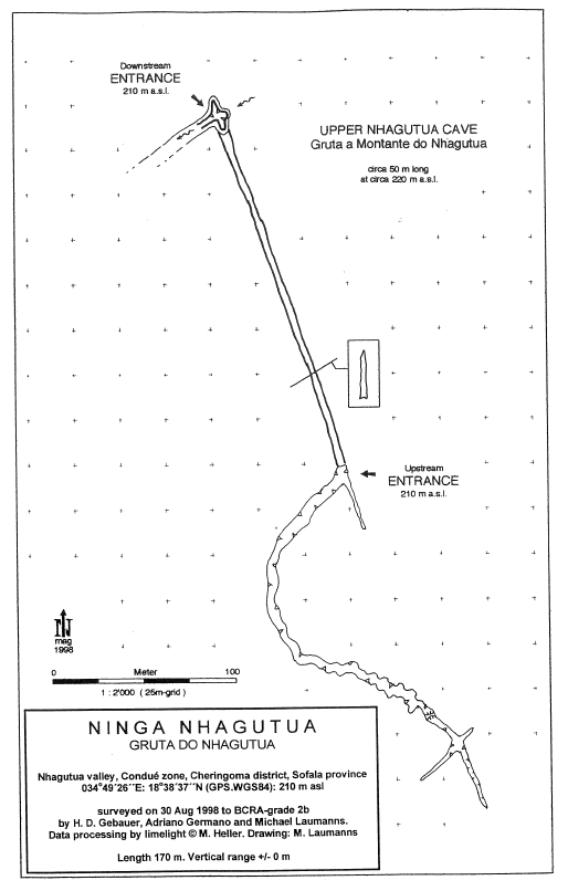
Nhagutua village, Condué zone, Cheringoma district, Sofala province. 34°49'26"E: 18°38'37"N (GPS WGS84), ca. 210 m asl. Surveyed on 30 Aug. 1998 by Herbert Daniel Gebauer, Adriano Germano and Michael Laumanns (BCRA-Grade 2b). Length: 170 m. Vertical range: +/-0 m. About 1 km W of Nhagutua village the Nhagutua river (also: Inhagutua river) which was dry during the field trip enters a spectacular karst gorge developed along a tectonic crack and influenced by the slight dip of the layers (to the W). The 40 m deep gorge features interesting corrosive and erosive phenomenon and contains stagnant water. After about 250 m of open canyon passage the Nhagatua river runs underground in a 170 m long totally linear rift passage with an average width of 6 m, a height of 30 m and a direction of SSE-NNW and continues afterwards in an open karst canyon. Ninga Nhagutua contains stagnant water (except in the wet season, when the whole karst canyon obviously is completely flooded) which is contaminated by the droppings of a big colony of the large bat species Hipposideros vittatus PETERS 1852. An even bigger lizard was seen in the water. Situated in a tectonic crack running parallel in a distance of about 100 m to the E in a slightly higher elevation at about 220 m as! another linear rift passage cave was found. The cave has a walkable horizontal entrance, a daylight window and carries flowing water used by the villagers for water supply. The length of this cave was estimated with 30 - 50 m. It was not mapped due to lack of time.
Caves nearby
| Distance (km) | Name | Length (m) | Depth (m) |
|---|---|---|---|
| 9.9 | Codzo River Cave [Grotte de la Rivière Codzo] | 942 | 33 |
| 9.9 | Upper Codzo River Cave | 40 | |
| 9.9 | Ninga Cupicua | 4 | |
| 9.9 | Mazamba Valley Caves | ||
| 10.2 | Ninga Niamabawa | 130 | 10 |
| 11.4 | Eastern Codzo Cave | 156 | 22 |
| 11.8 | Smaller Eastern Codzo Cave | 40 | 10 |
| 12.0 | Western Codzo Cave | 612 | 33 |
| 15.2 | Ninga Miriango | 610 | 10 |