Mujanga
-19.960667,34.132000
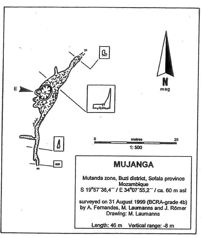
Location
Mutanda zone, Buzi district, Sofala province. GPS (WGS84) S 19°57'38,4” / E 34°07:55,2". ca. 60 m asl. From the parking place described under,Goonde No. 1° above, one has to walk the same footpath to the W until the above-mentioned path-crossing is reached. Walk straight ahead and follow a small path finally ascending the cliff on the Buzi bank, The cave is situated about 50 m N of the path where the way starts to descent steeply to the Buzi river level. When descending the path to the level of the Buzi a tobacco field is reached where a karst resurgence emerges with about 3 l/sec on the foot of the limestone cliff forming a small lake.
Description
General description
The entrance of Mujanga is a 5 m deep rectangular shaped pit (ladder) leading down into a small phreatic widened rift passage with the main directions N 45° and N 0°. The passage has small calcite formations and shows intensive corrosion phenomena. To the N and S it ends in low impenetrable bedding planes. No bats. No evidence of conglomerate infillings. An air temperature of 20,1°C was measured. Length: 46,00 m. Vertical range: -8,00 m. ml
History
Surveyed on 31. Aug. 1999 by Artur Fernandes, Michael Laumanns and Jens Römer (BCRA-Grade 4b).
Caves nearby
| Distance (km) | Name | Length (m) | Depth (m) |
|---|---|---|---|
| 0.4 | Goonde N°2 | 10 | 4 |
| 0.4 | Goonde N°3 | 131 | 10 |
| 0.4 | Goonde N°4 | 8 | 2 |
| 0.4 | Goonde N°5 and 6 | ||
| 0.6 | Goonde N°1 | 164 | 12 |
| 1.3 | Gruta Maruluwire | 114 | |
| 1.9 | Muchakaima N°1 [Bumba] | 42 | 12 |
| 2.5 | Chipayike n°1 | 115 | 8 |
| 2.6 | Muchakaima N°2, 3 and 4 |